Kaweah River Page - News Archive
08-06-11 The season is near end with flow finally dipping to a low of 400 cfs. There will still be enough water on the East Fork and Hospital Rock runs through the weekend.
06-20-11 A new High Resolution webcam is added at the location of the Kaweah-Cam. It features a high resolution 16x9 wide format image.
06-01-11 The South Fork was run from 3.5 miles above the Shatner put in over the holiday weekend. Flow was 1.5 feet on the South Fork gauge and run was reported to be quality Class V+ with a couple of easy portages.
This may change the previous perceptions that the South Fork above Shatner was too high overhead and not worth doing. You can judge for yourself with the following You Tube videos.
http://www.youtube.com/watch?v=9tZ8O0xeBHw
http://www.youtube.com/watch?v=fszBNAo3iyg
http://www.youtube.com/watch?v=rC0LWWEafs8
http://www.youtube.com/watch?v=NVcRLu-1glo
http://www.youtube.com/watch?v=kyOsPdWfFs0
http://www.youtube.com/watch?v=9oEj7nHFDTo
05-07-11 The Twitter upload via API has been solved by using a third party web based API Proxy to act as as intermediate between the application doing automated Twitter Tweets and the Twitter server thus olving the
Twitter "oauth" authentication problem that has kept kaweahriver from posting to Twitter for the last nine months. Thank you, SuperTweet.Net !
05-03-11 You Tube Video featuring Chase and Logan and other Kaweah locals up on the North Fork last Saturday. The young 14 year olds are becoming pretty
darm good boaters. Pretty good flow that day at 2.10 feet on the North Fork Gauge.
04-30-11 The Kaweah-Cam has been programmed to look for rafts in the image. Here you will find the latest Raft Watch Image
04-03-11 April 1st snowpack reports are in. The Kaweah basin has 175% of Average for April 1st. The Kings to the north has 172% of average, the Tule and Kern to the south have 215% and 196% of average respectively.
This is the 2nd largest April 1st snowpack since 1983. The other notable years were 1983 at 259% and 1998 at 185%. It has been pointed out that the April 1st snow survey may have under reported the snowpack. 21% density was
reported at Giant Forest. This number is uncharacteristically low and the actual density could be more like 40% which would make the Giant Forest survey more like 200% of average. The entire basin average may be more like 185%
if an adjustment in the Giant forest reading is taken into account.
02-12-11 The owner of the land river right immediately below No. 2 on the Park Boundary obviously does not want anybody on his land. The strange notification comes by way of a sign affixed to a boulder 50 yards
below the SCE bridge with the words: WARNING Experimental Rattlesnake Farm Keep Out. Word has it that the landowner will be building a house on the newly cleared area on a slight knoll
on the right bank between rapids No. 2 and No. 3. While a great site with a great beach of granite slab, the summer usage of the adjacent Edison Company land at the bridge by quantities of garbage leaving, graffiti marking,
undesireable, and unrespectful beachgoers will surely be causing them concern. The site rivals the Edison beach below Dinely Bridge where the ongoing war between landowners and beachgoers is an annual summertime issue.
The Park Boundary run will lose some of it's remote quality down the road.
02-06-11 With 2 of 5 stations reported, the Kaweah snowpack is 153% of average for March 1st. This may remain as an incomplete snowpack report since Sequoia Park missed the required window of opertunity to complete
the snow survey. Nevertheless, the snowpack is more than last year at this time and it will be a big water year.
01-07-11 The southern Sierra snowpack is on a record track of 250% of average. Currently at 95% of the April 1st average and 30% more than the record wet year of 1982-1983. The plot is available from CDEC at
http://cdec.water.ca.gov/cgi-progs/snow/PLOT_SWC and a cropped southern Sierra version of the CDEC full California snowpack plot now appears on this page.
12-11-10 Evan Garcia has posted a great video to vimeo.com of Boating the East Fork Kaweah in 2010. Check it out!
12-01-10 If you Google for Kaweah River you might find that The Kaweah River Page is Number One in Google. This has been the case on and off for many
years. No special methods have ever been used to try and improve the ranking of this page in any serch engine.
11-27-10 There is a new webcam coming soon to Kaweah Country. The new webcam will be located atop a mountain on private land. The view should be stunning. The entire system will be battery powered and solar
charged. An embedded real time timer powers the system up only at specific intervals thus reducing the battery and solar requirements significantly. The system is fully working "in the lab" including the microwave link
required to connect the remote site with the base station. Here you can see a photo of the Fully Operational Mockup of the Sierra Webcam less the solar panel which will be added at the time
of installation. The planned installation date is January of 2011. This project was inspired by the work of Glenn Cunningham and his newest Mineral King webcam with a view of Farewell Gap. The Farewell Gap webcam is also
fully battery/solar powered and also uses a radio data link to the base station.
09-19-10 March and April Boater and Kaweah News was moved to the News Archive.
09-18-10 Automatic daily Twitter updates of Kaweah River flow and Lake levels to http://www.twitter.com/kaweahriver using the command line program WGET 1.11.4 stopped working on Sept. 2, 2010 becuase Twitter
has diasabled "basic authentication" for updates via API. Twitter now requires a very complex authentication method using "Oauth". Googling the subject has left this novice programmer at a dead end with no immeadiate
solution. Therefore, Twitter flow and lake level automatic updates are suspended until further notice. If any reader out there has a solution for Windows 2000 please contact the webmaster of this page. FYI, formerly
sending tweets via the command line using wget 1.11.4 and "basic authentication" was as follows:
wget --keep-session-cookies --http-user=myusername --http-password=mypassword --post-data="status=Twitter Message Here" http://twitter.com:80/statuses/update.xml
09-12-10 River water temperature reporting is suspended for the season. The river temperature hit it's high for the year on August 27th when it warmed to 73.7 degrees in the late afternoon.
09-09-10 The webcam at the Chute is removed for the season.
09-09-10 The "Brian Rouch for Supervisor" sign in the foreground of the Kaweah-Cam is removed so it can be redeployed to a new location in the 4th District of Tulare County heading in to the November 3rd
general election where Brian and the incumbent face a runoff for the Supervisor position.
09-01-10 The Upper-Upper North Fork run will now be called the "Cherry Flat Section", so named by those who first descendedit this past june. The 5 mile run lies above the Upper North Fork walk-in run above
Yucca Creek and is accessed by Forest Service roads above Badger and a 30 minute hike to the river on a trail from the Cherry Flat area. The first 3 miles are very steep with one mile at 600+ feet/mile and the whitewater
is extreme by any measure. Surely this section is destined to became another Kaweah classic.
07-24-10 This weekend marks the end of the 2010 Kaweah Season. Low flow runs are possible on Hospital Rock and the East Fork but the lower runs are done for the year.
07-23-10 I took a bunch of pictures this year of commericial rafts trips at Gateway, The Chute, and Osterizer. If you were a KWA trip or other rafting company trip running from the uppermost Gateway putin at
the bridge on 6-13, 6-18, 6-19, 6-26, 6-29, 7-05, 7-12, 7-16, or 7-17 then you can look this fall on the Kaweah Pictures Page and see your photos. It is too much trouble to get all this stuff posted so it is delayed
as a early winter spare time project. Don't email asking for early release of the photos, I'll post it here when the photos are online.
Also got kayaking photos at The Chute and/or Extended Boundary on 7-9, 7-10, 7-11, and 7-14. Those photos will get posted this fall too.
07-18-10 We got more beta on the first descents earlier this season of the Upper Upper North Fork from 4 miles above the walk in run. Cody Howard, Kevin Smith, and Gino Hacker ran it at 1.4 feet on the North
Fork gauge and later returned to run it at 1.0 feet with Cody, Kevin, and one Mike. They hoped that some of the biggest stuff would be more runable with less water only to find the opposite to be true. Cody called the
Upper Upper North Fork to be "possibly the best steepest runable section of whitewater anywhere" Look for more action on this section in the future now that there is first hand data. Access is on forest service roads
near Badger and some brush whacking through chamise to get to the river. There should be some more coming documentation of this run in the blogs.
07-18-10 A green Dagger Nomad was found pinned on the Ash Mountain section on July 17th. It was pretty trashed and worn thin as a result of a long time in the river but the laws of river salvage prevailed and
all usable hardware was stripped and salvaged for spare parts. The hulk was left to tan in the sun somewhere. I suspect that there are more boats and paddles lost on Hopital Rock than we might think. The North Fork and
South Fork claim more than their fair share of equipment.
07-17-10 A successful first descent of the Upper-Upper East Fork from four miles above Horse Creek (six miles above the Lookout Point Trail was completed Friday, July 15-16, by the team of Cody Howard,
Nathan Hunkapillar, Culley Thomas, Macy Burnham, and Chris Tulley. They finished the run with a descent all the way down the Upper East Fork to the takeout at the Oak Grove Bridge. Soon after their just in time
takout they watched the river rise a foot in no time as a result of the thunder storm activity in the mountain during the day. A side trip a quarter mile up Horse Creek found some big drops including a 40 footer
that Cody ran. This leaves only the 1 mile section at 400 foot per mile above their run of last week as yet unrun water. The two miles and 1000 feet above this from the Atwell Mill trail was run in 2008 by some
of the same crew.
07-17-10 Strange thunder weather activity in the mountains the last three days ended with a mini flash flood Friday night that doubled the river flow in 4 hours. The Park Boundary jumped from 5.00 feet to
6.2 feet in three hours between 5PM and 8PM. The river started turning muddy at 9PM and by Saturday morning the flow had dropped but the Middle Fork was running brown/green and the East Fork was chocolate brown.
07-13-10 Your webmaster announced his retirement from kayaking as he has known it for the past 27 years, and 25 years on the Kaweah. From now on the upper runs including Gateway are off limits and kayaking
will be only casual Class 3 social boating at easy flows. I will continue to dilegently maintain the Kaweah River Page to the best of my ability and stay close to the the sport and the Kaweah, and close to all you guys
and gals who I have become friends with over the years on the Kaweah.
07-11-10 The Extended Boundary saw many runs in the last three days. Your webmaster entertained guests Masa San and Kenya San from Sacramento. Kenya San at thirteen years old demonstartated himself as a
solid Class 4+ boater with 4 runs on the Extended Boundary at levels of 5.20 feet to 5.45 feet on the Boundary gauge. He can be seen coming through the Chute at the completion of his Extended Boundary run on Saturday
as Picture fo The Day. Not only is Kenya the youngest ever to run the difficult Extended Boundary but his run at 5.45 feet is a very stout level at the high end of the normally runnable range. Kenya sports a bulletproof
hand roll on both sides that he used when a hole depaddled him and he hand rolled up out of the hole, ran the next drop hand paddling, and reteived his paddle no problem. Impressive! Watch for this youngster up on
Hospital Rock someday as soon as Dad gives him the OK. There was also some carnage up there by a boater going by K.P. (name withheld to protect the innocent) with nasty swims of Slalom on the Extended Boundary and
No. 1 from the top on the Boundary, calling it a day at the SCE Bridge.
07-02-10 There is a hazard dangling over the diversion dam at the Park Boundary. It is the Edison Company log boom that guards the intake facility for the flume serving Kaweah Plant No. 2. It has been
there ever since the peak flows washed it out and does not seem to be going away anytime soon. It is being held in place by the chain still attached to one end of the boom and the other end of the chain attached to
the top of the dam. As the boundary drops to runable levels in the next several weeks be aware of this hazard. The log boom is only a few feet right of the line that is normally taken to run the dam.
06-25-10 THERE WAS A FATALITY ON THE KAWEAH ON MONDAY, JUNE 21st. The victim was a 21 year old man from Florida on a commerical raft trip with All Outdoors. The flow was 1.7 feet on the Dinely Bridge
gauge and the water temperature was 50 degrees. The account that was heard goes something like this. I will try to be as general as possible as I was not there first hand and this is a third hand account.
The second of two rafts flipped at the bottom of Powerhouse. The resulting swimmers were separated with most on the left side in the moderate rapid below Powerhouse and the victim was swimming the right side. The
left side is the more serious water with substantial bedrock and stronger hydraulics and with far fewer opportunies to get out. While rescue of the swimmers was being facilitated by the upright raft on river left,
the victim was in a position where self rescue was the only option. Evidently he did not make it to the right bank before being swept down the right channel at Cyanotic. The further right one can get in the 1/4 mile
rapid between Powerhouse and Cyanotic the less problematic is a normal swim as the current lessens to the far right. A far right side swim is in Class 2/2+ water with a couple of short class 3's until one enters Cyanotic
where the rapid suddenly turns Class 4 with powerful hydraulics and one very large right channel wide pourover hole. Another 150 yards of very big whitewater follows the large hole until the river turns Class 2+ again.
The cause of death listed by the coronor was blunt force trauma.
06-16-10 The final runoff forecast for the 2010 season was released today. the five day period centered on July 3rd calls for a 50% probability of 1632 cfs average inflow into the lake. The equates
to about 1500 cfs at Three Rivers on the COE gauge. That also says Hospital Rock and the East Fork will still be cranking over the July 4th holiday.
06-15-10 The webcam at The Chute went back online at 17:30 today, Tuesday..
06-09-10 The private access road used to scout the dangerous low bridge on the South Fork Shatner Ranch run has been blocked by a new Berlin Wall iron gate. I'm not sure when this was installed but
it looks pretty new.
06-09-10 The Runoff Forecast released today reported the peak flow for the season at 11,000 acre-feet inflow to the lake on June 6th. This equates to a 24 hour average inflow of 5610 cfs. The actual
peak inflow exceeded the 50% probability estimate by 15%.
05-29-10 We hear from the campground volunteer at Buckeye Flat that a group of kayakers from Idaho ran Chucks Drop on Friday, May 28th. with 1100 cfs at Three Rivers.
05-28-10 The monumental task of creating and posting all the missing pictures from the 2008 and 2009 seasons is complete. The missing pictures for earlier years have also been posted. You can find
the new pictures by following the Pictures Page link. Some good stuff too from up on Hospital Rock, and a lot of Kaweah Whitewater Adventures rafting photos. The project took 3 days and 211MB of photos have been
added to the archive, more than anyone in his/her right mind would want to look at.
05-23-10 The Kaweah-Cam has been programmed to look for rafts in the image. Here you will find the latest Raft Watch Image
05-04-10 The May 1st snowpack report is showing the Kaweah drainage is 191% of average. This is a significant increase over April 1st and the largest May 1st snowpack since the 1998 El Nino year
when the May 1st snowpack was 248% of average. You can review all the previous Kaweah snowpack numbers from 1950 through 2010 at the Kaweah Snowpack Comparison Page
05-03-10 The Kaweah River Page reached 150,000 hits at 12:04PM Monday. The lucky visitor is from the IP address at 65.254.33.xxx located somewhere near Atlanta, GA. The visitor who had the 149,999th
hit at 11:41AM at IP 142.58.115.xxx in the San Francisco, CA area tried in vain to get the 150,000th hit by reloading the page 6 times but was denied the victory because the hit counter ignores multiple consecutive
hits from the same source. The screenshot of the hitcounter was recorded for posterity as it happened.
04-27-10 The History of The Kaweah River Page was updated for the first time since being published 5 years ago. You can find the link at the bottom of this page.
04-21-10 The weekly runoff forecast was released by CNRFC today, April 21. The 50% probability forecast for the peak one day average inflow to the lake has been increased to be 4335 cfs on May 27th.
04-21-10 The recent rain storm has dumped over 2 inches of rain at the lower elevations and 20 inches of snow at Farewell Gap at 9500 feet.
04-14-10 The Kaweah River Page endorses BRIAN ROUCH FOR TULARE COUNTY SUPERVISOR, 4th DISTRICT. Yes, it's Brian Rouch, the same Brian and the first and only kayaker to be featured in the banner
photo at the top of this web page. Brian is not only one of the original local Kaweah River kayakers but his family has a long history in the local San Joaquin Valley agricultural community. Read about Brian's
election campaign at his website. http://www.brianrouch.com . The 4th District includes northern Tulare County but does not include Three Rivers which is part of the 1st
District. The Banner Ad at the top of this page is a first for this page. The Ad will remain up until the election on June 8th. Brian will be pretty busy during the election campaign but we hope to see him on
the river again after the election. This July will mark the 10 year anniversary for Brian as the "banner boater" at the top of this page.
04-12-10 The April 1st snowpack report shows the Kaweah drainage at 138% of Average. The lower elevation snowpack is even higher with 195% of average at 6400 feet. Two winter storms since the snow
survey was taken are pushing April to be a better than normal snowpack accumulator. The rains and lack of hot weather are keeping Kaweah country nice and green. April 1st Snowpack of the neigboring drainages:
Kings River 107%, Tule River 181%, Kern River 123%.
The California Snow Water Content Page at CDEC is a good page to watch to follow the snowpack accumulation by region. The latest graph for the
southern section shows the affect of the storms since April 1st.
03-24-10 The link directly below has been corrected so you will get the correct "Snowpack Comparison" page.
03-15-10 The Snowpack Comparison page is updated with the 2010 snowpack data clearly showing we are on track for a runoff similar to 2005 and 2006.
03-14-10 The March 1st Kaweah snowpack is in. It's 143% of average with 4 of 5 stations reported. Still on track for a big water runoff. Very high snowpack at the lower elevations means a stellar
North Fork season. The Tule River snowpack is a whopping 339% of average and the Kern River has 130% of average with 13 of 14 stations reported. To the north the Kings River is reporting only 99% of average.
02-22-10 Last week on Wednesday and Thursday, Feb 17-18, the really warm days, a bunch of folks ran Hospital Rock from Buckeye Flat to Zero To Sixty. This was the lowest flow run on record as there
was insufficient water below the SCE diversion of 60 cfs above Zero to Sixty. The Hospital Rock gauge was 3.90 feet on Wednesday and 4.00 feet on Thursday. They were boating on 120cfs/140cfs respectively. They
reported the run was great all the way to the diversion dam where the water ran out.
02-21-10 We have heard from Southern California Edison that their project to report the gauge data from their gauges on the East Fork and Hospital Rock to the internet will not be completed for the
2010 spring runoff. The delay is related to a bigger project where they are replacing a large amount of hardware with a newer system and they want to wait and make the reporting system part of the new hardware
system. They have not forgotten us. The project is only delayed.
02-04-10 The Kaweah snowpack is 148% of average for Feb 1st. At this rate it is going to be a big water spring runoff and extended boating season. It is an El Nino year.
10-26-09 In early September a trip to the Hospital Rock venue at 25 cfs found that Little Niagara is extremely undercut explaining how paddles are
often lost in this drop. It can scare you to see what the riverbed looks like without water in it. Little Niagara would not be a place you would want to find yourself in the undercut behind the falls!!!
10-26-09 A 25 cfs low water exploration trip found the Upper Cave below Zero to Sixty goes way back upstream to the right below the drop and
The Exit to the Cave is steep and can not be exited from water level without ropes even in the summer when the cave is dry and slime free.
10-25-09 After the flood of Oct 14th the previously removed Steel Channel Beam below The Chute became buried in 3 feet of fresh sand.
10-23-09 The Oct. 2009 Flood has it's own page here.
10-23-09 The Oct. 2009 Flood is compared to the past floods of 2002 and 1997 on the Kaweah River Flood Comparisons Page . In a nutshell, the 2009 flood
was only 25% of the 1997 flood in terms of total volume and 69% of the 2002 flood.
10-23-09 The 4 day water temperature graph is replaced with the graph showing water temperature for the entire 2009 season. The graph is no being longer updated after Oct 21, 2009.
10-22-09 The Kaweah-Cam Page has been updated with some links to all the the Kaweah-Cam images for the Flood of Oct. 14, 2009
10-20-09 The river water temperature sensing was removed from the river for the rainy season so as not to risk loss of the hardware in the event of another flood. The graph remains static
for now on this page. You can still click the graph to get the entire 2009 water temperature graph.
10-20-09 I was provided this update on post flood changes to the Gateway run. Hammer is wider on the left where willows have been stripped out but has a piton rock at the bottom.
As to be expected, Powerhouse is a whole new rapid where a large amount of rock moved turning this all time class 4 into a class 3. Flattened out and teeth removed you can now see all the way down
the rapid from the top. The old right center channel has returned but a little bit of tree mitigation will be needed to make the new right center safe. The left center channel has some willows in
the path that will also need to be mitigated. The right channel in the rapid below Screaming Right Turn, just below Salt Creek, has been further narrowed and dewatered, a turn for the worse. Nearly
all water goes left down the modified rock and debris jumbled mess rapid that now has no defined route, just a bouldery boat bonking mess. Rafts can expect problems here next season as there is no
way through at normal flows. This rapid was worsened in the 2002 flood and the recent flood has contined the downgrade.
10-18-09 Taylor Cavin and Justin Patt ran the East Fork on Saturday and report that there are no new hazards and the river boats pretty much the same. A couplde of new logs are clearly
visible and not an issue. They ran Hospital Rock on Sunday and report no changes to that run also.
10-14-09 A major flood occurred overnight. Moderate rain all day on Tuesday, Oct 13th, caused the river to start rising very slowly all day but the knee of the flow curve did not occurr
until late in the evening Tuesday. 10PM flow at Pumpkin Hollow was about 100cfs and at 11PM the flow had jumped to 1000cfs. By 1AM Wednesday the river was cranking an estimated 4000cfs at Pumpkin
Hollow. The river rose at a frantic pace between 1AM and 4AM when finally the rate of rise declined. The river remained at it's peak flow between 5AM and 6AM before starting to receed before daybreak.
The river reached a peak flow of 11 feet on the river gauge trees seen in the right hand side of the Kaweah Cam image and 11 feet on the flood marker in the foreground of the Kaweah Cam image. Flow at
Pumpkin Hollow was raging at 1AM while the COE gauge in Three Rivers was reporting only 320cfs for the same hour. Your webmaster was up all night monitoring the flood and posting updates often to the
Message of the Day on this page. As far as we can tell the flow on the Kaweah above the North Fork was about the same as the flood of Nov 8, 2002.
10-04-09 A Double Rainbow was captured by the Moro Rock Webcam at 6Pm on October 4th
09-28-09 A 21 foot long, 620 pound, 12x3 inch Steel Channel Beam was discovered 100 yards below The Chute. It took five days of work to get the beam out of the river and winch it 100 feet
downstream and up onto the right bank into a 500 year flood safe location. The next flood could have sent this hazardous debris downstream where it could have become lodged in a dangerous location
between some of the mega boulders in Headwall Rapid and right in the path of boating. Hopefully we can get this beam cut up into smaller pieces someday for easier permanent removal from the river
vicinity. There are about 20 more steel beams similar to this one scattered in the two miles below the Southern California Edison Bridge at the Park Boundary. That bridge partially washed out in the
flood of January 1997 leaving alot of hazardous steel in the river ever since. At least one beam is in a very dangerous position crosswise to the current in the middle of a commonly run drop above
No. 11 on the Park Boundary run. You can follow the beam removal project with this series of three photos.
Steel Channel Beam partially removed from the river
Steel Channel Beam out of the river and on the bank
Steel Channel Beam in it's final flood safe location
09-13-09 Two drownings occurred this summer on the Kaweah. Such a tragic but avoidable loss of life. The drwonings occurred on successive days and both in the same spot adjacent the beach at
the end of the paved trail to the river at Hospital Rock. The site is sometimes referred to as the "Toilet Boil", and for good reason as the entire river flows under a twenty foot high boulder on river
left into a near perfect death trap sieve. Kayakers putting in here for the Hospital Rock run or finishing the Buckeye Flat section avoid this spot like the plague as it is obviously a place you don't
want any part of. Portaging or putting in below the hazard is the only thing to do here. Here are a few pictures of the hazard taken at slightly less flow than when the accidents occurred but by no
means a lesser hazard at this lower flow. Moving water generates very high forces and this spot is a hazard at any flow level. Swimmers, please stay away at at times!
The site of the drownings
Closeup of the sieve beneath the boulder
Sequoia National Park Signage posted at the accident site
08-19-09 Good news to report regarding Kaweah gauging. Southern California Edison Company has acknowledged the need for public access to their real time flow data on the gauges at
Hospital Rock, the Park Boundary and the East Fork. The project is in the works at Edison and may or may not be ready for the 2010 boating season. This is not without real cost to Edison as
hardware, custom programming, and web site creation is involved. Sincere thanks go out to Edison for their expense, time and effort in this project.
07-10-09 You can now click the Water Temperature Graph to get the graph for the entire 2009 season, May 23rd to present.
07-04-09 The Kaweah Commonwealth posted a blurb that kaweahriver was on Twitter. Also noted was the once nearly daily tweats had fallen off along with the water levels. This is true.
07-03-09 The Kaweah season is declared done for 2009. Too low to boat on all streaches except boat bonking below town to the lake.
06-29-09 There is another great writeup out there regarding an East Fork run on June 9th with the group of Eric and Rebecca Giddens, Jason, Trevor and Geno at a Park Boundary flow of 4.90 ft.
(840 cfs peak the night before at Thrre Rivers) This link to Eric Giddens' Writeup on the East Forkhas alot of great photos including a sequence of Trevor
running Dead Man's Alley in various states of instability. Good reading! Appologies that I don't have all the last names at this time. The blog goes on to document the following day on Hospital Rock.
06-27-09 Ben Stookesberry and Darin McQuoid made the third known decent of the Upper Middle Fork from Panther Creek to Buckeye Flat Campground in a two day expedition with only one day
on the river June 14-15, 2009. The 3 mile run from Panther Creek (River Mile 64.1) to Chucks Drop (River Mile 61.1) drops 1120 feet (370 ft/mile average) from the put in elevation of 3840 feet to
the take out at the trail crossing above Chucks Drop at elevation 2720 feet. They had a flow range at the Three Rivers COE gauge of 540 to 740 cfs. You can check out
Darin's Upper Middle Fork Kaweah Report June 14-15, 2009
for a great writeup.
- The team of Cody Howard, Erik Boomer, Dan Laham, and Scott Baker made the second know descent of this section April 15-17 of this year with 525 to 680 cfs recorded on the Three Rivers gauge. With
April flow contributions from the North Fork the real flow at Three Rivers would have been less by about 100 cfs of this number. They reported the flow to be about as much as one would want for this
section. Scott abandoned the run above the mandatory Rusty's Rampage after an unsuccessful portage, abandoning his boat and hiking out reaching the takeout 24 hours later. The writeup on
Cody, Erik, Dan, and Scott's Upper Middle Fork Kaweah April 15-17, 2009 is well worth reading.
- Both descents of the Upper Middle Fork this year were shorter by some 5 miles or more than the epic first descent May 26-31, 2004 by Scott Lindgren, Shannon Carrol, Matze Brustiman, Steve Fisher,
Rusty Sage, Taylor Robertson, and Jason Hale at 475 to 840 cfs on the Three Rivers gauge. This first descent was a 6 day affair that originated on Cliff Creek somewhere above it's Middle Fork confluence
(confluence is river mile 68.3 at elevation 4840 feet). The first descent allegedly claimed 3 broken paddles at Rusty's Rampage near the end of the Panther Creek gorge. The first descent is part of the
Scott Lindgren Production "Burning Time 2" available on DVD from
Scott Lindgren Productions
06-09-09 Chris Fairchild is again Picture of the Day with an outcome hard to believe if it wasn't caught by the camera. Yes, sports fans, this is Chris 1/2 second later from his move on
the lip of Little Niagara seen in yesterday's Picture of the Day.
06-07-09 Some boaters will do anything to be immortalized as Picture of the Day. With competition stiff for today's spot, and so many great runner-up photos, Chris Fairchild took the
challenge to a new level with a patented move on the lip of Little Niagara that is not likely repeatable by anyone but the patent holder himself. Possibly the most extreme kayaking yet seen in the
nine years of The Picture of the Day.
05-31-09 Josh Bruckner made his Picture of the Day debut today up on Hospital Rock. There were several other great runs on the V-slide today but only room for one Picture of the Day.
The level was a fairly meaty 5.0 2PM reading on the Hospital Rock gauge. Sorry KWA rafters, I had some good shots of you guys too but Josh on the V-Slide was over the top.
05-30-09 Picture of the Day today was hard to chose. I had several good shots to choose from. In the end Tex Osterizing his KWA paddlers won in the tossup.
05-30-09 We just heard that yours truly is featured in a recent LVM video being interviewed on the history of the Kaweah. I haven't seen the DVD yet but I only hope I look as stupid as
most of those that came before me doing LVM interviews. 8^)
05-29-09 Hospital Rock and The East Fork have dropped to runable flows for the coming weekend.
05-27-09 A new webcam at The Chute has been added bringing the webcam count to four. The webcam at The Chute is seasonal and subject to withdrawal if it looks like rain.
05-26-09 The Boater News for January through March 2009 has been moved to the News Archive.
05-25-09 The water temperature graph was added to the page today. Please ignore the bogus 55 degrees filler data prior to midday May 23rd.
05-23-09 The water temperature sensor was re-installed in the river and is now updating every 15 minutes in both Fahrenheit and Celcius in the "Current Weather Information" section of this
page. As soon as we get 4 days worth of data the 4 day water temperature graph will be posted too.
05-20-09 Today's DWR runoff forecast predicts the 50% probable flow at 1734 cfs average inflow to the lake for the next 5 days steadily diminishing to 1000 cfs by the weekend of June 6th.
05-18-09 The Kaweah has peaked for the 2009 runoff season at 2665 cfs early this morning at midnight. Lower flows from here on out.
05-15-09 The Kaweah-Cam captured one Kaweah Whitewater Adventures boat passing by the webcam Friday morning with a load of commercial rafting customers.
Kaweah-Cam 2009-05-15 11:05:06 The Kaweah-Cam is programmed to capture images every 20 seconds between 10:45 and 11:15 every morning in the hopes of
catching a passing KWA raft. Images can only be captured every 20 seconds with upload to the internet invoked so it is likely that some boats will go undetected when the river is moving fast like
it is now at levels above 1.5 ft on the Dinely Gauge.
05-13-09 Today's DWR runoff forecast predicts the 50% probable flow at 2346 cfs average inflow to the lake by the middle of next week. Peak flow prediction moves out 4 days to May 18th
with the peak one day inflow to Lake Kaweah at 2805 cfs.
05-09-09 The Kaweah-Cam captured Two Kaweah Whitewater Adventures boats passing by the webcam Saturday morning with a load of commercial rafting customers.
Kaweah-Cam 2009-05-09 10:55:36 and
Kaweah-Cam 2009-05-09 10:56:43
05-07-09 The Kaweah River Page has joined Twitter. Find us at http://twitter.com/kaweahriver on the Twitter Page. Those of you reading the
Kaweah River Page directly will likely not need Twitter as anything posted to twitter will also appear here in the "Message Of The Day" and/or "Boater and Kaweah News". Twitter does provide us an
an additional avenue for distributing Kaweah River updates to those on mobile devices.
05-06-09 Today's runoff forecast indicates a fairly steady runoff at 1734 cfs average inflow to the lake for the next 2 weeks with higher upside potential. Peak flow prediction remains at
2550 cfs average inflow to the lake on May 14th, the peak flow occurring 4 days sooner than last weeks forecast.
05-05-09 The May 1st snowpack report is done. The Kaweah basin has 79% of normal snowpack for May 1st. Last year it was 71% on May 1st. With similar weather to 2008 the boating season
should go through the 4th of July weekend for kayaking but end the week before for rafting. The Kaweah basin reports much higher May 1st snowpack than the Kings, Tule, and Kern basins so there is
always a chance the 79% number could be a bit high. Hard to imagine one lttle drainage could have so much more snow than everything else on all sides.
05-01-09 The May 1st snowpack report is still coming in... With 2 of 5 stations reported the Kaweah basin is reported at 98% of May 1st average. However, don't count your chickens before
they are hatched! The adjacent Kings (Apr/May 83%/64%), Tule (Apr/May 76%/31%), and Kern (Apr/May 73%/34%) river basins are all showing a dramatic reduction in May 1st average snowpack vs. April 1st.
in their May 1st partial reports. Compare the reports for
April 1st 2009 and
May 1st 2009 for yourself.
I had made an earlier prediction for a reduced Kaweah snowpack at 45% of May 1st average. While the final Kaweah May 1st number may not be as low as 45%, it certainly will be less than the 98% partial
report figure.
04-29-09 The weekly runoff report released today indicates near constant runoff for the next four five day periods averaging 1428 cfs average daily inflow into the lake.
04-28-09 Your KRP webmaster had a successful rotator cuff shoulder surgery on Monday. The surgeon says the repair will be very strong due to the exact nature of the tear. Now the somewhat
rough recovery period begins. I'll be back on the river next season good as new.
04-28-09 The morning Kaweah-Kam image from the Kaweah Commonwealth shows an improved wider field of view and a cleaned lens. Thanks for the improvement John!
04-26-09 The Eugene Register-Guard (Oregon) published an
article on April 24, 2009
featuring an interview with Macy Burnham concerning the death of his father, Jon Burnham, on the Kern River last week.
04-22-09 A new weekly runoff report was released this morning by DWR and it shows the effect of the recent unseasonably warm weather. Peak flow date remains predicted at 2550 cfs average
inflow to the lake on May 18th. The new runoff graph is posted below.
04-21-09 It is with deepest sadness that we must report the death of Jon Burnham, 63, on the Kern River at Carson Falls last Friday April 17th. John is the father of Macy and Jake Burnham.
John's son Macy is one of the well known paddlers frequently seen on the extreme sections of the Kaweah River where the East Fork is his prefered venue. While I never met John personally it is obvious
he had a zest for life and was still out paddling the hard stuff. Our thoughts and prayers are with John's family.
An article at canoekayak.com has more information about the tragedy.
04-20-09 It is reported that a group ran the Upper Middle Fork from 5 miles above Buckeye Flat near Cliff Creek. The hike-in event spanned Fri/Sat/Sun and it is reported to be a must do
to for the extreme types. Only Cody Howard's name is known so far along with ~3 others. Updates will appear here as they are known.
04-19-09 The Kaweah-Cam captured two kayakers in the 1PM Kaweah-Cam Image as they passed the webcam. Yellow boat in front and red-orange boat
behind. It's Jeff and Eric from Fresno. Very rare indeed to actually capture boaters in the webcam.
04-15-09 The first runoff forecast of 2009 was released today and the graph is posted below in the Spring Runoff section. The 2009 peak flow date is initially predicted for May 18, 2009
at 2550 cfs average inflow to Lake Kaweah. The 50% probability flow on May 2nd is 1480 cfs average daily inflow into Lake Kaweah. Inflow to the lake is the sum of all tributaries.
04-08-09 That group of 19 kayakers seen back on March 23rd was from The World Class Kayak Academy in Montana. They spent a few days in Three Rivers and up running the Hospital Rock section.
You can read about their trip to Three Rivers on their WCKA Blog Page and in the
Kaweah Commonwealth March 27 - April 2 edition Volume 18, No 13. where their visit was featured on the front page. The front page
can also be downloaded as a PDF file here.
Kaweah Commonwealth March 27 - April 2 edition (Front Page PDF) . Yours truly was out on the beach that day and caught
them after coming through The Chute. I talked to one fellow and tried to get them to eddy out for 3 minutes where they would have been captured in a group shot in the next Kaweah-Cam but the leaders
were already heading downstream into Headwall. Bummer, the Kaweah-Cam would have loved to have you guys documented in the Kaweah-Cam archive.
04-04-09 April 1st snowpack in neighboring basins is as follows: Kings 83%, Tule 76%, Kern 74%.
04-03-09 Hospital Rock below Zero to Sixty was 4.70 feet at 4PM Thursday, April 2.
04-02-09 The April 1st snowpack report is starting to come in. The Kaweah drainage is at a low 77% of normal snowpack for April 1. The dry March and early runoff has taken a big
toll on the snowpack. This year is comparable to 2007, another low water year. At this rate Kaweah boating will go through the first or second week of June depending on above/below normal
April precipitation. This means a good Class 5 year on the East Fork and Hospital Rock with the friendlier lower flows but a poor rafting year with low flows and a shortened season on the main
Kaweah. It may be that the season highest flow on the North Fork will be Friday, April 3rd but still not up to the 1.40 ft level for the normal run from Yucca Flat to Paradise Beach.
03-28-09 The East Fork, Hospital Rock, Park Boundary, Gateway, Dinely, and North Fork above Yucca Creek are all runnable this weekend. The North Fork below Yucca Creek still
needs more water to get to the 1.40 ft minimum level.
03-27-09 The first Picture of the Day for 2009 features Keith Kishiyama and Luke Liebsch on the East Fork portage below Sky Hook on a March 21st 175 cfs low water run.
03-27-09 Kaweah Snow Survey Data from 1950 to present has been consolodated into an easy to read data page. Get it Here (200kB web page)
(With the addition of the 1950 data this document is done. DWR data only goes back to 1950)
03-23-09 Nineteen kayakers, which must be some sort of record number, came down the Gateway section on Monday. They were on a low flow run. Weekend flow would have been higher.
03-22-09 Nathan Hunkapiller, Macy Burnham, Chris Tulley, Keith Kishiyama, Peter Mulkin, and Luke Liebsch ran the East Fork Saturday at the low flow of about 175 cfs.
They ran Hospital Rock Sunday and claimed to have plenty of water. The North Fork was low at 1.1 ft Sunday on the Bailey Bridge Gauge but the Upper Upper north Fork saw some runs made on
weekend with plenty of water reported.
03-17-09 The Kaweah-Cam has some new floodwatch features. Two trees on the right side of the field of view have new river level markings. The sycamore tree nearest the river is
marked from 6 feet to 12 feet and the cottonwood tree 30 feet up the bank is marked from 8 feet to 13 feet. A post in the foreground marks the flood level of Nov. 8, 2002 at 10.5 feet.
All levels are in feet above August pool level. It takes about 3000 cfs for the river to reach the first marking at 6 feet above pool level so these markings are for flood conditions only.
The 500 year flood of Jan. 2, 1997 is estimated to have been between 14 and 15 feet above pool level.
03-02-09 The March 1 snowpack report is showing 107% of March 1 average with 4 0f 5 stations reported. The high elevation snowpack is between 65% and 89% of April 1 average
but low elevation Giant Forest snowpack at 6400 feet is 156% of April 1 average. This means more early season runoff and possibly a North Fork boating season but it doesn't help in
extending the boating season as June and July runoff comes from the high elevation snow fields. High elevation snowpack is between 85% and 95% of average for March 1.
03-02-09 The Kaweah Webcams now upload 6:00AM through 8:30PM inclusive. It has become too much overhead to continually need to adjust the webcam hours with sunrise/sunset
changes and daylight saving time adjustments. You will therefore see a dark image at the beginning and end of the day other than during June and July. The kaweah-cam page now contains
a rotating archive of the last 60 images.
02-25-09 The Boater and Kaweah News from July through Dec 2008 has been moved to the News Archive.
02-24-09 Surgury on the webmasters shoulder will be April 27th. No boating in 2009 for the webmaster. :^(
02-13-09 The snowpack has grown significantly since the Feb 1 report. We may be close to normal snowpack now. More winter storms will be coming through for the next few days.
This link to the 2009 California Snowpack Graphs shows the current snowpack progress along with with several helpful trendlines.
02-04-09 The Feb. 1st snowpack report is coming in now. The Kaweah drainage is at 79% of average. Neighboring Kings and Kern drainages are at 67% and 60% respectively. With
the winter more than half over we are heading for a very low water year and short boating season. A low water year translates into a banner Class 5 season as the steep upper stretches
will be at runnable levels most of the snowmelt season.
01-23-09 OK, the jury is in. Your webmaster is headed for surgery on his shoulder and will indeed miss the 2009 boating season. I finally got to see the orthopedic surgeon
and Kaiser is scheduling surgeries for May, about the time boating is getting into full swing. Kaiser healthcare sucks. It will be 6 months from the time of my injury until the time I
get into surgery. So much for what you get in return for $7000 per year for medical insurance.
01-03-09 Degrees Celcius has been added to the quarter hourly Current Weather Information image above for our metric and European fans. The Kaweahcam page now supports the new
Kaweah-Cam and it includes a rolling 3 days worth of archiving of past images.
01-02-09 Your KRP webmaster is on shore leave. A recent MRI has confirmed that your webmaster sustained a "Torn Supraspinatus Tendon" in his right shoulder as a result of a
Nov. 15, 2008 mountainbike ride in the Salt Creek BLM area. Something popped while straining on the 18% uphill that day and two subsequent falls on the arm/shoulder have only made it worse.
Surgery may be next and it is looking grim for participation in upcoming 2009 kayaking season. The 2009 daily Sequoia Park road cycling routine is also in jeopardy. Mountainbiking is out.
12-18-08 A new floodwatch page was tested recently and worked perfectly. Look forward to awesome real time coverage of rising river conditions in the event of a major rain
event and rising river levels. Two webcams will be providing 640x480 images every 5 minutes. The Kaweahcam Page will switch to Floodwatch when the need arises.
12-18-08 The issue of Kaweah River Pictures Page, Kaweahcam, Weatherstation, and other KRP extensions, webpage unavailabilty has been solved. It turned out that the phone line
providing the DSL service to the webserver that serves those pages and files was intermittant because squirrels had eaten through the phone line seveal weeks ago. The phone line was
replaced on 2008-12-17 and the IP address of the Kaweah River Pictures Page server should again remain static for a long time and server available 24x7. Sorry for the inconvenience. On the
plus side, necessity is the mother of invention, and the webcams now upload more reliably to the server at c2.com. More webcams with reliable uploads all came out of this disaster.
12-13-08 The Ash Peaks and Moro Rock webcams now have timestamps embedded in the images. Since the webcams have no provision for including a timestamp it took some programming
in PERL combined with an upgrade to Irfanview 4.10 with the needed support for command line driven batch processing to embed the text under program control.
12-11-08 A page has been added with all three webcams and the current temperature
12-09-08 For those of you who can't find or have given up finding the 15 rock formations in the Kaweah-Cam image, here is the
KEY
12-07-08 A link to The Silver City Webcam on the way up to Mineral King is added in the Kaweahcam section below.
12-07-08 The server at 71.111.xxx.xxx that serves some extended portions of this page is crashing somewhat often and may be down when you try to access pages there.
12-06-08 The bihourly uploads of the three new webcam images is apparently a little sporadic. Not sure of the reason but a couple changes have been made that might help.
12-02-08 Strange rock formations have been seen growing in the new Kaweah-Cam field of view. There are 15 in all, try to find them all. Hint, one is only one high and one is
right behind/over the other. There will surely be less than 15 if the river comes up even slightly.
12-01-08 The Moro Rock Webcam image is added. The Ash Peaks webcam image is now cropped to eliminate unnessessary foreground foliage.
11-29-08 The KRP has contacted Southern California Edison Co. requesting that three of their river gauges be made available to the public on the internet. Those gauges are
located at The Park Boundary on The Middle Fork one half mile up from The East Fork confluence, just below Zero to Sixty on the Hospital Rock section of the Middle Fork a half mile above
The Marble Fork confluence, and a half mile above the Oak Grove Bridge on The East Fork. We will be waiting to see if Edison can be pursuaded to make their data available to the public.
11-29-08 1PM The Kaweah-Cam and Ash Peaks Cam are now being uploaded to the C2 server every 30 minutes during daylight hours
11-25-08 6PM It is with great sadness that we must inform of the passing of Gordon E. Wood this afternoon. Gordon had a lifelong connection with Kaweah country and the Mineral
King Valley. Gordon, a brilliant retired aerospace engineer is best known around here the last few years for creating the two remote webcams in Mineral King. Gordon will be missed by all
whose lives he touched including myself. Gordon, we will think of you everytime we view The Mineral King Webcam
11-25-08 10AM The new Kaweah-Cam is online and uploading images every 30 minutes 24x7.
11-23-08 11PM The server that provides the kaweahcam, message of the day, and weather data is back up again but on a new IP address.
11-23-08 10AM The server that provides the kaweahcam, message of the day, and weather data is down since 11-21 at 2PM and will be down until further notice. A new kaweahcam
is installed and will start reporting hourly as soon as I get some scripting in place. In the meantime see the new kaweahcam image as it was on Saturday afternoon, Nov 22. The new
kaweahcam is a view of the river about 50 yards upstream of the old location and should provide a more dramatic picture of the flow during times of more flow. The river is more channeled
through some quite large boulders that will become significant whitewater at higher flows.
11-02-08 A Saturday night rainstorm that dumped 2 inches of rain in the mountains below 9000 feet brought the river up to a runnable level. The river was already falling by
daybreak Sunday. Jeff Gymer, Sean Sangree, Evan Lloyd, and yours truly ran the Gateway section to Dinely at 0.6 feet. The river dropped 0.25 feet from 0.85 feet just 2 hours earlier
when we ran the shuttle. By the end of the Gateweay run the Park Boundary had dropped to sane flows so Jeff, Sean, and Evan ran the Boundary at 5.35 feet. Other than the brown water,
it was a good day with warm air and water. I don't know whether to call this the last run of 2008 or the first run of the 2009 season. We should probably call this the first run of
2009 since we were all in new boats. The webmaster's maiden voyage in his new Liquidlogic Remix 59 is commemorated with The Picture of The Day. By the way, I really like the new Remix
59! Despite 17 years in a Dagger Freefall LT the new short boat was easy to adjust to.
10-29-08 The webmasters Freefall LT is not weldable. The plastic just gets soft and stretches when heated. The plastic will not melt no matter how hot it becomes. I am pretty
sure it is made of crosslinked plastic. The crack has been gasketeded and maetal straps replaced. The boat is relegated to guest boat B status.
10-09-08 The KRP Webmaster's New Kayak is a Liquidlogic Remix 59, white (Pearl) with "Surfer" Graphics. I won't know how it really
boats in actual whitewater until the river comes up again but the boat came high claims from the Liquidlogic Rep Ted Keyes at the recent annual Alder Creek Kayak Supply fall sale in
Portland. White with the flowery graphics would not have been my normal first choice but the $750 sale price for the brand new boat was an over riding factor. This is a big day for
your webmaster to be moving to a modern short boat after boating the last 18 years in a Dagger Freefall LT. My boater buddies have been twisting my arm for several years now to upgrade
to a new boat. So last year it was the new road bike and now it's a new kayak. Don't worry, you will still recognize me on the water, the helmet is the same old one you are used to.
09-06-08 Today's late summer Picture of The Day features yours truly, KRP Webmaster Bill Pooley, paddling the Spreewald in Germany. Class Zero but quite an experience with
hundreds of others out on the River Spree doing the same thing. Many thanks to my hosts Hagen and Marius Krueger for a fine day of paddling with nice lunch stop along the paddle route.
Do a Google search on "Spreewald" if you want more info.
(Die heutige 'Aufnahme Des Tages' zeigt den KRP webmaster Bill Pooley persoenlich im Spreewald, suedlich von Berlin, Deutschland, paddeln. Ein aufregendes Paddelerlebnis auf der
Spree trotz nur Stufe Null mit vielen anderen zusammen. Vielen Dank an meine Gastgeber und Begleiter, Hagen und Marius Krueger, fuer den hervorragenden Tag auf der Spree mit einem
urigen Spreewaelder Mittagessen. Fuer mehr information ist eine Google Suche "Spreewald" empfohlen.)
07-15-08 The water temperature data collection and graph is removed for the season.
07-15-08 A Monday evening thunderstorm brought only the second rain event since late March. Heavy rain in the mountains caused the river to spike to 800cfs at midnight and
turn to mud. There would have been enough water to kayak this morning if one could tolerate the muddy water.
07-09-08 Macy Burnham sent in some great shots for some encore Pictures of The Day for 2008. Go to the Picture of The Day section below to check it out
07-09-08 All the 2008 Boater news through June is moved to the News Archive.
07-06-08 Brain Rouch and yours truly did the 5 mile run below Lake Kaweah today. The 2500 cfs release from Lake Kaweah made the run go pretty quick. We passed two groups of
inner tubers also doing the run. Besides the usual mandatory Portage at the McKays Point diversion dam there was one other portage at an ugly 6 foot high pile of broken conrete stuffed
full of logs and probably rebar too. From below after the portage it looked like there was a narrow route right in the middle which would be very blind from above and missing the line
would not have been a good thing. We did the run in 2 hours even taking time to surf at McKays Point which is commemorated with today's Picture of The Day.
07-04-08 A detailed description with photos is finally published for the Extended Park Boundary Run. The link is below in the "Kaweah River Descriptions by Section" portion
of this webpage.
07-03-08 There will be some encore Pictures of The Day posted from time to time as new material becomes available
07-01-08 Brian Rouch and John Nelson did a very low flow Hospital Rock run at 360 cfs on the Three Rivers gauge and 4.25 ft on the Hospital Rock gauge. This is pretty much as
low as you can go on Hosptial Rock. This equates to boating on 170 cfs at the put in and 120 cfs at the take out.
06-30-08 Five KWA rafts were seen scraping their way down the river today. I'm sure it got worse before it got better.
06-29-08 Ah, the end of the Kaweah season! It was finished off with a bang. A passle of boaters, no less than 13 run the East Fork on Saturday with a passel up on Hospital
Rock to boot. Your webmaster has ended the season with 2 great runs on the Extended Boundary where Mike Hauber quickly adopted the name Super Boundary due to it's notch up in difficulty
compared to the normal Park Boundary run. I used to call the Extended Boundary a Class 5 but since I am not a class 5 boater and I ran everything with perfect line and no difficulty I
guess I need to downgrade the rating to 4+ at lower flow but still Class 5 with moderate or highr flow. (But, please boys and girls don't go on this stretch with anything less than strong
Class 4 technical skills! A Picture of The Day commemorates the occation and maybe an encore POTD will follow soon.
06-26-08 Rush Sturges' boat was found today on the East Fork several drops downstream of Dead Mans Alley. It is cracked and at the present time it is a large piece of East Fork
litter on the right bank. Still no sign of the box containing the camera still somewhere on the river.
06-22-08 Editorial: There is a brewing controversy regarding the beach at Southern California Edison Kaweah Plant #2 on Kaweah River Drive as abuse of the privilege to use
the area is likely to end up the same as the BLM North Fork sites, total closure. The few parking spaces and lack of any sanitation facilities in causing illegal parking and a
sanitation issue among other issues like alcohol. So many people, mostly non locals from down in the valley, flock to the beach each weekend and are overloading it's intended capacity.
Southern California Edison Company does not seem interested in patroling their property and enforcing policy. Last evening I experienced a total lack of respect when a car sat blocking
the one lane road for 5 minutes while they loaded their car. They seemed to be in no hurry to clear the road so I honkled from my waiting point up the road. When they fianlly loaded and
drove past me I made a comment out the window that the road was not a loading zone. What came back was a very scary string of profanity and all hands out the window in the sign of the
bird. The car sat and the bird signs continued until I was out of sight down the road. The local residents do not deserve this kind of abusive rage. Enough is enough. A long time
advocate of public river access I have watched the situation steadily degrade the last few years since Edison openly posted the beach as open to the public. I now say close it permanently.
There are public river access points up in the national park that are patroled by the park rangers and volunteers. Let the beach goers pay their park fees and go where abuse is not tolerated.
06-20-08 Epic Hospital Rock run ends in hike out in total darkness. Three Fresno boaters put on late on Hospital Rock. Two of the three have never done the run before.
After a quarter mile one newbee calls it quits and takes the easy hike to the road still nearby. Just below the Four Twenty Gorge the two remaining guys both swim at the same time.
One boat gets pinned, one paddle is pinned but visible and the other paddle is gonners. Eventually retreiving the pinned boat and paddle they are now relegated to hiking out in the
dwindling light because they have no spare paddle. The hike out takes 90 minutes in the dark clammoring through thick chemise and likely poison oak. A park ranger kindly gives them
a ride back to their car. Personally, I'd worry alot more more about the pending case of poison oak than replacing the lost paddle. There must a few morals in this one....... And, as
usual you can collect your 6 pack for the safe retuern of the paddle. Seems like more than the normal average of lost paddles this season.
06-20-08 Two days ago on the 18th Young Guns Productions' Rush Sturges pinned his boat underwater in the left most slot in the drop above Dead Mans Alley on the East Fork.
Rush got out but the boat is still pinned in there. The pelican box containing the expensive HD video camera was last seen plunging into Dead Mans Alley not be be seen again and it is
told that Rush climbed out of the canyon in bare feet. You can bet there is at least a case of cold ones waiting the person who comes up with the camera. Rest assured tha camera is in
there somewhere.
06-19-08 The Kaweah River water temperature graph is added to this page so you don't have to mess with finding it on the weather station page.
06-17-08 This coming weekend and probably the next will be premier weekends for Hospital Rock and East Fork flows. Sane water levels and pretty warm water.
06-17-08 For those of you inquiring about flows for rafting this coming weekend, well, my guess is that there will be enough water for rafting the Kaweah from Gateway down
for the last weekend this season. Forecast is continued hot weather which is keeping the river up against a rapidly declining snowpack. We are loosing about 70 cfs per day now.
Weekend 11AM Saturday flows are likely to be in the 750 cfs range or 0.5 ft at Dinely Bridge. It will be a rock dodging run for rafts but still plenty of water for kayaks. Powerhouse
will be a bit boney as the entrance is squeezed down to a matter of feet. So there you have, this will be the last weekend for commercial rafting the upper run above Dinely Bridge.
06-16-08 The past weekend saw a foiled attempt at running the Upper Upper East Fork from the Atwell Hockett trail crossing at 5920 ft. to the Lookout Point trail at 3360 ft.
Nathan Hunkapiller, Macy Burnham, and Chris Tulley navigated about 1000 vertical feet and 2.2 miles of the canyon ultimately realizing that the full 7.5 run would not be possible in the
two days allocated due to the extensive scouting required of the long gorged in rapids. The 1200 foot climb out of the canyon took 7 hours on Sunday. Read Nathan's posting on the
Boof.Com Forum chronicling the event. Previously thought to be a first descent by this web page, it has evidentally been run
before. This page is waiting word on the details of the first descent of this extreme section. One of Nathan's photos is appropriately today's Picture of the Day.
06-14-08 Last night resulted in some interesting boater stories from the Lower East Fork, the last 2 miles of the noraml run. Not listening to the wisdom of their webmaster,
the local Three Rivers boys (no names please!) put in pretty late at 4:30 PM on their maiden voyage down this section. Flow was quite high for a first time down this section especially
considering my buddies here are not quite fully Class 5 dudes. Nevertheless, they made it down the canyon exiting right at dark. Too dark to boat any further they took out at the
bridge and still donning boater gear went straight to the bar at The Gateway where it was a very late night with some good stories to tell. Portaging a few of the most heinous drops
provided some of the best stories, one of which was a mountain goat ordeal with 45 foot seal launch at 50 miles per hour bouncing off ledges. Another portage resulted in a paddle
accidentally dropped off the cliff into a pool where quick action of jumping in after it pulled off the save followed by rope extraction from the pool. Portaging intensified in the last
half mile as the sun disappeared and the water swelled under them from the days snowmelt catching up with the weary but adrenaline stoked boaters. Good job guys! I should have never
thought for a minute that you would be booking a night in Room 101 at the Ledge Rock Motel.
06-13-08 We now know the cause of the mudflow on The East Fork the afternoon of June 9. The Edison Flume feeding Kaweah Plant #1 from above the Oak Grove Bridge broke at Old
Bear Ranch dumping 25cfs straight down the mountain side into the river 1.0 miles above the Middle Fork confluence. My estimate is that 75,000 cubic feet of water came crashing down the
mountain side in the 3 hours it took to drain the 3 miles of flume above the break. The Mineral King road was partially washed out because the 12 inch culvert could not handle the flow.
The road has since been repaired but you can see the evidence where water had been flowing in the road for 200 yards.
06-12-08 With a dwindling snowpack offset by rising teperatures into triple digits this weekend predicting weekend flows is more difficult but I am going to guess that flows will
remain nearly the same with evening peaks of 1200 to 1500 cfs throughout the weekend.
06-11-08 Thanks to Chris Tulley we have a picture of the New Anchor Bolts at the risky Dead Mans Alley Portage on the East Fork. These
bolts will be seeing some duty in the next few weeks as the East Fork drops to runnable flows.
06-09-08 The East Fork turned muddy for 3 hours between 4PM and 7PM today. The cause is unknown but likely a mudslide up toward
Mineral King somewhere. There was no rain or thunder clouds visible over the Sierras at the time. The river cleared up as fast as it had turned to mud. The North Carolina boaters missed
a muddy water takout by an hour.
06-09-08 North Carolina boaters Chris Gragtmans, Adam Secrest, Clayton Gaar, Daniel Windham, and Robin Betz ran from Hospital Rock all the way to below the East Fork confluence
in one epic 7 mile run. The Hospital Rock gauge was high at 5.6 feet. The high water required five portages, one at Zero to Sixty on the Hospital Rock section and four more portages on
the Ash Mountain section below the Marble Fork. They all ran the gorge behind the Ash Mtn. park headquarters including Iron Lung at the cliff jumping gorge. Their overall assemment of the
Ash Mtn. section was that it is not as clean as Hospital Rock, has some monster holes, has some very quality rapids, and they would not have wanted any more water. The Ash Mtn. section
is much less run than Hospital Rock, maybe seeing only 10 percent of the useage vs. Hospital Rock but is every bit as difficult.
06-08-08 North Carolina boaters Chris Gragtmans, Adam Secrest, Clayton Gaar, Daniel Windham, and Robin Betz took a day off from Class 5 kaying to scout the Iron Lung gorge
below Ash Mtn. park headquarters. Not to be outdone by any of the local cliff jumpers they all partook in jumping from the 45 foot level on river left. Claytons back flip from 35 feet
on river right made Picture of The Day. You can find the photo in the Picture of The Day archive for 6-08-08. "Four Beers" Daniel Windham and "Two Beers" Robin Betz joined me for the
Gateway evening run on the main Kaweah. I saw lines on that run I did not know existed and I have paddled this river for 25 years.
06-07-08 Saturday morning flows are up substantially. 5.85 ft. on the Park Boundary at 8AM. Hospital Rock and The East Fork are both at higher flows than last weekend and
will be going higher yet tomorrow, Sunday. Both are very high and out of range for almost all.
06-06-08 My cracked boat is repaired with an ingenious solution worthy of my degree as a Mechanical Engineer. Since I now drive a
contraption more reminiscent of a Ben Hur Chariot you just might want to stay out of my way.
06-06-08 Yours truly, the webmaster cracked his boat on the Park Boundary run yesterday evening. Flow was 5.3 ft on the Boundary gauge and
I T-boned the shark fin rock half way down No. 1 above the SCE bridge. Unaware of the damage and boating with less than full control for the next four miles, I was surprised to find
my boat full up with water at the takeout. Repair in the form of a cross bolt thru the nose are being contenplated. In the meantime a temporary fix
will have to do.
06-04-08 The latest and final runoff forecast for 2008 was released today by DWR. Average inflow to the lake is predicted to be abovwe 1000 cfs through June 21.
Barring any heatwaves this equates to kayaking through the end of June and rafting from Gateway through the weekend of June 21-22.
06-03-08 The Old Anchor Bolt at the risky Dead Mans Alley Portage on the East Fork was replaced by a group of East Fork boaters
on Sat., May 31, 2008. The new system includes a pair of 3/8 x 3 inch bolts with chain between them in a Y arraingment. The group came prepared with a battery hammer drill to
facilitate the installation. This is good news for all East Fork boaters who had rightfully so questioned the old anchor for years.
06-03-08 The river continues to gradually come up a bit more each day. Wednesday is forecast be the secondary peak flow for this season. Wednesday is forecast to be
5 degrees cooler so Thursday flow should have the same flow as Wednesday. Rising temperatures back to the low to mid 80's through the weekend should should keep flows at slightly
higher than last weekend. This coming weekeknd Hospital Rock is estimated to be slightly on the high side and the East Fork will be high.
06-02-08 Peter Malkin is Picture of The Day for the second day in a row. His Sunday run at Zero to Sixty on Hospital Rock was too good to go unaknowledged.
06-01-08 Lost paddle today on the Hospital Rock section in the cave on river right below Zero to Sixty. Email the webmaster if you find it and collect your six pack
reward. A little side note here, the boater swept into the cave was extracted through the upstream back door of the cave but exiting the cave does require a rope and aid from above.
It is not possible self extract ones self from the cave but one can find a stable position while awaiting rescue from above. The boat was pulled out downstream by a long rope.
06-01-08 Carnage on the Park Boundary run at 5.5 ft on the gauge. An unsuccessful attempt to run Portgae No. 11 at too high of a flow resulted in the kayaker getting
stuffed into the undercut rock, getting chundered in the hole and barely getting out after an extended swim in the hole and a swim all the way through the drop above the restraunt.
His boat went at least 3/4 of a mile before it was corraled just above Willows. Please folks, have a little respect for No. 11 on the Boundary. It is a very dangerous drop and
has been responsible for several mishaps this season. Thankfully nobody has been killed yet at this very hazardous location. See this spot at no water and you will understand the
danger.
05-31-08 There was some carnage up on the East Fork today. A two man run ended soon with a verical pin just below the alternate putin below the slab rock with the
kayaker nose down and hull pointing downstream. A very dangerous situation. The second boater dislodged the first while running the drop but because the first boater was facing
body upstream he got nailed in the chin by the second boat and sustained a bone deep gash to the chin. They both ended up swimming out of the hole after going 10 feet deep in
the suction. Took them an hour and half to get back upstream a hundred yards to the putin point to exit the gorge. The East Fork is running a bit high right now and will be
going up more tomorrow. Stories like this are not unusual on the East Fork. While I'm at it, how about the 19 year old who slipped in while scouting Dead Mans Alley and swam
the entire set of Class V+ drops before hiking back up and running it with his boat the second time? Plenty more stories just like that one.
05-29-08 Hospital Rock is definitely runnable this weekend with todays afternoon flow estimated at 375 cfs above the diversion dam and 325 cfs below the diversion
dam. The East Fork is estimated to be flowing 250cfs based on a 6PM takeout time, maybe still a bit too high for most boaters.
05-28-08 Hospital Rock was run today by Aaron Root and three Whitewater Voyages guides in two rafts. They report to have run everything. I watched from high above
on the road for 45 minutes as they scouted and finally ran Zero to Sixty just below the upper Edison diversion dam.
05-28-08 The weekly runoff forecast released today predicts a slow rising trend to 1430 cfs average inflow to the lake by June 4th then the start of the declining
flows to season end. 1430 cfs average inflow equates to about 1250 cfs at Three Rivers or 1.05 ft on the Dinely Gauge during mid day boating hours. Barring another heat wave
soon, I will predict that we have seen the last of the high water. Safe and sane boating from here out, but a little boney for the rafters. The Class V season on the East
Fork and Hospital Rock is coming soon.
05-26-08 It was a very cold and wet Memorial Day weekend. There were a few boaters seen on the river but certainly no locals except Mike and Dave were out today
for a cool run on The Park Boundary. It must have been an uncomfortable weekend on the river for those commercial rafting patrons. More seasonable weather is returning later
this week.
05-23-08 Hospital Rock will again be runable for the Holiday weekend if you can stand near winter conditions and 45 degree water. Cold weather has snow falling
above 6500 ft for the next couple days. Expect gradually falling river levels through the holiday weekend. Commercial rafters better bundle up, it's going to be a cold day
on the river. Cooler than normal weather is in the forecast through late next week.
05-21-08 The DWR runoff forecast released today downgrades the flow rates from last weeks predictions. 50% probable flows will be above 1200 cfs inflow through
June 7th. See the new graph in the Spring Runoff Section below.
05-21-08 Many of you are wondering where all the pictures are of this years boating, especially the KWA rafting photos. Be patient, I will post here when I get
the photos postprocessed and uploaded to the Pictures Page. I have KWA photos coming for trips on May 3, 4, 10, 18, 19, 21. And kayaking pics coming for a bunch of other
days too.
05-20-08 4PM Kaweah River Water Temperature is again being reported in the Current Weather Information section above.
05-20-08 Kaweah Whitewater guides Frank Root, Aaron Root, Scott Welsh, Mike Welsh, Grace Ogawa, Haley Jules, Taylor Randle, and Noe Figeroa ran from Dinely
Bridge in two rafts to above the Tunnel of love at midnight last night under a full moon at 3000 cfs right when the river was peaking for the day! James McCloud kayaked
the midnight run with them. The glow stick on James' helmet led the way. KWA does a yearly moonlight run but this one was at the highest flow possible for the year and
the first know moonlight run for a kayaker. The gauge at Dinely Bridge was probably 2.6 to 2.7 ft at the time of the run. Well done guys and gals! Don't expect midnight
commercial runs to be offered anytime soon. ;)
05-20-08 8AM Tuesday stage at Dinely Bridge is 2.25 ft.
05-19-08 The previously questioned COE/Dreamflows flow discrepency is retracted. Seems to have been my operator error.
05-18-08 Check out this photo of The Chute at 8PM Sunday evening The flow is estimated at 2900cfs and is going
way over the boulder at the top right of the main drop! The river has come up from 1850 cfs to 2900 cfs in 4 hours.
05-18-08 The river was flowing 2000 cfs today (2.0 ft on the Dinely gauge) when the KWA saftey kayaker, James McCloud, did a full on backflip in the Chute.
This picture captured the kayak as it started launching like a nuclear missle from a submarine.
05-16-08 A heat wave is in progress and the river is coming up substantially every evening to higher and higher flows. Expect 300 cfs increases each
day for the next three days.
05-14-08 Today's runoff forecast predicts the peak inflow to the lake at 2550 cfs average on May 19
05-10-08 The latest runoff forecast has downgraded the peak flow to 2040 cfs average inflow to the lake on May 28. Peak midday flows at Dinely Bridge
are not likely to exceed 1.5 ft for the remainder of this season. Good flows below Pumpkin Hollow Bridge, but a bit high for Hospital Rock and the East Fork for
the next three weeks.
05-09-08 Two paddles are lost about 2 weeks ago, one on the Upper North Fork above Yucca Creek and one on the Park Boundary. Contact Dave Hammond at
The Three Rivers Hideaway if you find one. Surely there is a 6 pack waiting for you if you are the lucky finder.
05-05-08 The Picture of The Day Archive has been caught up with several shots from the 2008 season
05-05-08 The May 1st snowpack report is nearly complete. Kaweah snowpack has dwindled to 71% of May 1st average with 4 of 5 stations reported. Peak
flow is now predicted for May 28th at 2520cfs average.
04-25-08 Brian Rouch is the first 'Picture of the Day' this spring 2008. You remember Brian, you see him every time you load this page in the banner
at the top of the page. Only the boat looks any different from the Brian you are used to seeing. The photo was taken on the evening run in the main drop above
the Gateway on the Boundary Run. The flow was 5.2 ft on the boundary gauge.
04-23-08 The first runoff forecast of the 2008 season is posted. Peaks flows are predicted for the first and second week of May at 2200cfs average.
03-07-08 Steve Larson at the Bakersfield BLM office has confirmed that the North Fork Closure is still in effect for the 2008 boating season.
The closure technically includes using BLM land for river access. Again, Yucca Flat is not subject to the closure so the Upper North Fork hike in run is still
open. There is more bad news too. The BLM is not likely to make any changes in the the North Fork Closure for the next 3 years. A new management plan is
scheduled for that time frame. Also, BLM resurveyed the Paradise site in June of 2007 and found that the Paradise Beach site is on private land that is part
of the Elliot Ranch. The parking lot gate at Paradise Beach is on BLM land but land upstream of the gate including the parking area is private land. BLM land
extends downstream of the gate for about a quarter mile and is subject to the closure order. BLM is planning a public meeting in Three Rivers sometime in April
where this closure will be among the topics. The meeting will be announced in the Kaweah Commonwealth when the scheduled date is known.
02-28-08 It appears that the North Fork Kaweah BLM sites of Paradise Beach, Advance Site, and Cherry Falls remain closed and gated
for the 2008 boating season. The
North Fork Kaweah BLM Closure Notice
posted May 8, 2007 on the Bakersfield BLM website appears to be still in effect for 2008. The closure notice page was last updated Jan 18, 2008.
I have a call in to the Bakersfield BLM office requesting an official update on the closure status for the 2008 boating season. I will post an
update here as soon as I know more. The Yucca Flat parking area at the confluence of Yucca Creek is exempt from this closure notice. So before
you go boating on the North Fork and get fined $1000 and/or get 12 months in prison better read the closure notice and don't leave your car in
any unathorized areas. The last time I was up the North Fork the entire road was posted No Parking from Bailey Bridge all the way up.
02-28-08 The March
Snowpack Report from the Department of Water Resources will be updating during the
next week. Reload the report often to see the latest snowpack numbers. A significant winter storm added to the snowpack during the 3rd week of February.
01-25-08 Watch for the February
Snowpack Report from the Department of Water Resources that will be coming out soon.
This will be the first snowpack report of this season with Kaweah River snowpack data. I am expecting a good start to the snowpack for 2008.
01-20-08 An update appeared in
The Kaweah Commonwealth Newspaper Friday, Jan. 18, 2008 edition
after your webmaster emailed the editor at the Kaweah Commonwealth. Boaters in the previous weeks article were named as well as some good press for this webpage.
01-06-08 The group of Jeff Gymer, Evan Lloyd, Sean Sangree, and yours truly the webmaster ran the falling but still muddy river in cold conditions
at 0.1 feet on the Dinely Gauge, about 700 cfs on the Gateway section. A picture of our run made the front page of
The Kaweah Commonwealth Newspaper Friday, Jan. 11, 2008 edition. (Link opens PDF of the front page)
01-05-08 Heavy rains of 10+ inches in the Sierras up to 7000 ft caused the river to rise from 100 cfs to at 6PM to 7000 cfs at 1AM the next morning.
Continuous updates were being posted to the Pumpkin hollow Weatherstation Page monitoring the very fast rise.
05-01-07 The group of Devin Knight, Shon Bollock, Garrett Brown, Jason Hollerman, Eric Petlock and Taylor Robertson, and Darin McQuoid
ran The East Fork on 4-28-07 when the mid day flow at Three Rivers was 900cfs (1200cfs midnight peak at Three Rivers the night before) Their trip
is well documented with photos at
Darin McQuoid's East Fork Trip Report
04-27-07 The latest runoff frecast moves the peak flow in the April 30 at 1120 cfs average inflow to the lake. Expect a very short season
possibly ending by the third week in May with flows at Three Rivers not exceeding 700cfs except during the weekend of April 28-29.
04-11-07 The first runoff forecast of the season was released today. Peak flow is forecast to occurr on May 4 at 1020cfs daily inflow to the lake
04-02-07 HAZARD WARNING ON THE EAST FORK! 0.6 miles below the Oak Grove Bridge put-in at the second big drop, the drop
with a huge tilted slab against the wall now has a new car sized slab blocking the river. The portage requires ropes and is described as tricky
with 4 boaters. Higher flows or fewer boaters increases the risks. East Fork flow was low, probably 140 cfs, on Apr. 1, the day of the encounter.
It is possible to put in below this hazard with some imagination.
04-02-07 The April 1st snaowpack report is in from DWR. The Kaweah drainage has only 41 percent of normal snowpack. With the unseasonably
warm spring and runnable flows already here expect a very short boating season but the low flow will allow a longer than usual spring season of Class V
on Hospital Rock and the East Fork.
04-01-07 North Fork is below runnable levels and Hospital Rock and the East Fork are at very low levels, too low for most folks.
03-15-07 Unseasonably warm weather has the river running higher each day. Boaters have already been seen on the river this week.
But, the penalty for this warm weather is March is going to be a very short boating season in May, and probably none in June.
03-04-07 March 1 snowpack in 86% of average for March 1st
02-06-07 Feb 1 snowpack report is in from DWR. Kaweah basin snowpack continues to be at a very low level this year,
43% of normal for Feb 1st. Snowoack is also low for adjacent rivers with 36% of normal in the Kings River basin and 25% in the Kern River basin.
01-07-07 Realtime Snowpack Comparison between 2007 and 2006. Use this link to track
the snowpack as the 2007 snowpack progresses.
01-06-07 The Kaweah Snowpack for 2007 is off to a slow start. Estimated snowpack is only 25% of the level we
had on this same day last year. The Kaweah drainage snowpack is probably at only 40% of normal
09-09-06 The current time-temperature image above in now updated every 15 minutes
08-12-06 The Kaweah Flow Graph from dreamflows is back. Chris changed the image format from a gif to a png
08-12-06 The Picture of the Day archive has been updated with 15 additional photos for the 2006 season. There are now 30 photos for 2006.
08-11-06 The Kaweah River below The Pumpkin Hollow Bridge has finally cleared to a reasonable clarity.
08-11-06 The dreamflows.com Kaweah flow graph from dreamflows.com has not updated since july 31st. Hey Chris, what's going on?
07-30-06 The East Fork pictures from the July 8th trip are finally posted on the Pictures Page! Enjoy.
07-28-06 Water remains less than clear. Current depth of visibility is 54 inches at Pumpkin Hollow.
07-26-06 The river remains moderately muddy and uninviting. Here is a photo of a cross section of the mud deposit from 7-21 or what I like to call
Kaweah Layer Cake . The entire river bed is lined with this stuff. No longer does the Kaweah have it's normal pristine clean
sandy bed so famous for late summer swimming. This ugly layer of thick dark mud is going to be in the river until the winter rains bring the river back up with
enough flow to clean it up. The best swimming this summer is up on the Middle Fork above the Park Boundary where the river was unaffected by the mudslide on the
East Fork.
07-22-06 6AM. Water color is still chocolate brown due to the washout on The East Fork Thursday.
07-21-06 7AM. The river is running dark chocolate brown as a result of the thunderstorms yesterday. The source of the brown water is The East Fork.
The Middle Fork above the East Fork confluence is running fairly clean.
07-20-06 8PM. The level at Dinely Bridge is 1.10 ft and rising now. Thunderstorms in the mountains all day has cause the Kaweah to run real
whitewater yet again. The Dinely gauge was at zero ft at 7PM and has come up a foot in one hour. River is still rising and running a light shade of brown.
07-18-06 Gary, that was some good boating with you the last few days. Next year try for more water and lower dollars/mile.
07-18-06 The seldom run "Extended Boundary" run from the gorge below Iron Lung to the Park Boundary adds 3/4 mile of Class 4 to Class 5 water to
the regular Boundary Run. More difficult than the Boundary run with a complex 250 yards of Class 5 that is avoided by taking the Wheelchair Branch. The putin
is accessed by the easy 7 minute downhill trail leading to the cliff jumping site below Ash Mountain Park Headquarters.
07-15-06 The body of the woman missing on the East Fork was found on Wednesday slightly below Oak Grove Bridge
07-10-06 Possibly the best Picture of the Day ever posted. It doesn't get much bigger than this.
07-10-06 The Hospital Rock photos from Sunday are on the Pictures Page. I still need to do the Saturday East Fork pictures. Enjoy.
07-09-06 A Kaweah River Page First! Special today, 3 Pictures of The Day, The Good, The Bad and The Ugly. Click the links a little further down.
I am working diligently at the moment turning the weekend East Fork and Hospital Rick photos into webpages for the Pictures Page. Stand by.
07-07-06 The riverbed at Dinely Bridge has sunk another 0.2 ft. since last year. The Dinely gauge now reads 0.2 ft. lower now for the same flow
compared to one year ago. This is an ongoing phenomenon. The riverbed at Dinely Bridge has dropped more than a foot in the last 10 years. There will still be
plenty of water for kayaking when the gauge hits zero. The gauge has been dug out so it can be read. 0.35 ft. at 7PM Fri.
07-03-06 Attention East Fork boaters! The body of the 21 year old woman lost on the East Fork below Oak Grove Bridge on June 24th will most
likely be located by kayakers running the East Fork this season. Please keep an eye out. The East Fork will probably at runnable flow by this coming weekend.
07-02-06 Clover Creek up in the National Park had a large visitation by steep creekers today. The flow was low but the fun was high.
The photos are on the Kaweah Pictures Page. Follow the link to the pictures page further down this page. Where is Clover Creek you say? Click the link to
the Map of Clover Creek and the Upper Marble Fork at Lodgepole (500kB image). Clover Creek is done for this season but put
it in your plans for next year. Runnable flow is when the Kaweah at Three Rivers drops to 1400 cfs peak at midnight.
06-30-06 The "Picture of the Day" is back.
06-30-06 Three Lost Paddles on Wed 6-28 on the Hospital Rock run.
Werner Carbon Fiber Bent Shaft black with black electrical tape on grips, AT paddle with yellow blades, Aquabound 4 piece breakdown.
Please contact the KRP webmaster or Dave Hammond at the Three Rivers Hideaway
06-30-06 Very hot weather for the last several weeks has had the Kaweah at very high flows. In the last few days the flow has started
to drop significantly. The hot weather is going to significantly shorten what was hoped to be an extended season through July. Hosptal Rock will be
dialing in in the next few days. Give the East Fork another 10 days for the flow to drop to Class 5 levels.
06-30-06 Finally the KRP is getting updated. New high security on the c2 server has your webmaster having to
to learn a whole new protocol to update this page.
06-20-06 Thank you Kaweah Whitewater Adventures! Your's truly and his guests Markus and Erma from Dresden, Germany has a great run
with you at 1.7 ft on the gauge. We had perfect rafting conditions. It was this webmasters first raft trip on the Kaweah after more than 20 years
of kayaking the Kaweah.
05-25-06 ATTENTION customers of Kaweah Whitewater Adventures! The old url to the KWA website was hyjacked by an unscruplous person.
The new KWA address is http://www.kaweah-whitewater.com
05-02-06 The May 1 Kaweah drainage snowpack report is reporting 187 percent of average snowpack for May 1 compared to 166 percent of average
for the same date last year
05-02-06 The lake elevation is 690 ft., 4 feet below the old spillway level. Lower Holiday is already buried by the lake for the season.
03-26-06 Realtime Snowpack Comparison between 2005 and 2006. This will give you a
good forwardlooking estimate of the potential runoff flows. For comparison 2005 was a high water year.
03-22-06 Three weeks of continuous snowfall in the mountains has raised the snowpack to levels near last year at this same time. Expect a
big water runnoff. The North Fork should run for several weeks due to the large low level snowpack.
03-03-06 The Mar. 1 snowpack report is published by DWR with 4 of 5 stations reporting. The Kaweah basin is 104% of average for Mar. 1.
Mild weather during Feb. has resulted in a net loss of average snaowpack. Last year at this time the average was 152% of average and in 2004, a low
water year, the average was 104% of average on Mar. 1. The North Fork ran only one weekend in 2004, but 2004 was a banner year on Hospital Rock and
the East Fork with low flows providing continuous class V runnable water throughout the spring.
02-13-06 The Feb. 1 snowpack report is published by DWR. The Kaweah basin is 111% of average for Feb. 1. Continuing mild weather the first
two weeks of Feb. is no doubt diminishing that number.
01-28-06 The oldest news from this section has been moved to the news archive.
01-01-06 Wow! The 8000 pound black rock that lay on the right side of Chute up against the bottom right mega boulder is GONE, washed away
in the high water yesterday, 12-31-05.
This Photo taken today, Jan 1, at 500 cfs clearly shows the rock is missing. The rock that had layed tight up against
the right side mega boulder in 2004 had pulled away from the wall about 18 inches during the spring high water of 2005 creating a slot between the rock and the wall.
The day before it washed out I was pondering if the rock might go in the next high water because it looked so precarious in it's current position with not much holding
it there. This probably means The Chute has a better line now and the rapid is improved.
12-31-05 5PM. The Kaweah peaked at 4PM. Flow at Dinely Bridge was 3.8 feet at 4PM, (4000 cfs). Rain has stopped and the river is receeding.
No further updates are planned tonight. The COE gauging is still broken. Estimated peak inflow to Lake Kaweah was 7000 to 8000 cfs.
12-31-05 3PM. An intense rain storm has dumped 1.4 inches of rain in Three Rivers between 5AM and 3PM. The river is currently raging at an estimated
4000 cfs at Pumpkin Hollow and is still rising. The webcam is being updated every 15 minutes in the last 2 hours of daylight. Updates via the Message-of-the-Day
will continue into the evening until the river stops rising. The COE gauge is not reporting so this page will do it's best to keep it's readers, including
Tulare County and NWS officials informed of new developments. Wind estimated at 40 mph at 2PM has toppled numerous trees in the Three Rivers area.
12-02-05 The first winter storm of the season dumped 1.7 inches of rain on the Kaweah at 1200 ft. elevation and 4.0 inches of rain at
6400 feet elevation. The snow level was 7000 feet. 20 inches of snow fell at the 9400 foot level. The river quickly rose from 10 cfs to 2500
cfs in 10 hours. The North Fork peaked at 2.5 feet at 1:30PM. There just might be enough water still running on Saturday for a winter run.
10-25-05 The Message of the Day section of the page was added to allow the webmaster to remotely post a short information message.
10-25-05 A widespread power outage in Three Rivers from 2:10AM to 10:40AM today prevented hourly updates of the Kaweahcam and Weatherstation data during the outage.
10-16-05 Current Three Rivers temperature reporting was added to the main page
07-24-05 The computer that serves the Webcam and the Weatherstation is working again for the time being
07-24-05 The Park Boundary was 4.80 ft. at 5PM Sunday and was runnable all weekend. KWA was still running commercial trips this weekend from Gateway, rocky but still barely runnable.
07-14-05 I have no way to actually read the gauge at Dinely Bridge but I say the reading is 0.6 ft. today 4PM based on the COE flow to Dinely Bridge relationship
when there is negligible North Fork contribution. Hospital Rock and the East Fork are at optimal flows. Enjoy it while you can. The extreme hot weather will probably end the Kaweah season in a week.
P.S. Your webmaster really misses the Kaweahcam, Rivergauge and Weatherstation data. I look forward to repairing the Kaweah server and getting this data back on the WWW.
07-12-05 The computer that operates the webcam and weatherstaion crashed on 7-11-05. It will be September before it can be repaired. Sincere apologies for the
inconvenience. The Kaweahcam page and Weather page continue to operate but the data is frozen at the time of the crash.
07-07-05 The river gauge and water temperature graphs are removed from the main page. The last recorded copy of the data is frozen on the rivergauge page.
07-06-05 The river guage and water temperature recording will be going offline for the 2005 season on 7-7-05. I hoped you found the data of interest
while it was in operation. The Kaweahcam has ceased operation from The Chute as of 8PM tonight. The webmaster is vacating the Kaweah for this season to return to
his other life in the corporate world. There are 2 to 3 weeks weeks of boating left on the Kaweah and the Hospital Rock and East Fork runs will be coming in to runnable
range in the next few days. The recent very hot weather is blowing out the remaining snowpack at an incredible rate.
06-30-05 Your webmaster appologizes for the lack up updates to this page. He has been to busy with domestic duties and has been relagated to shore
leave by way of injury sustained while boating an evening run two days ago. An extended brace in Riverway while tryiong a new route at 1.4 ft resulted in a
sprained elbow. Your webmaster is probably laid up for the remainder of the boating season and is pretty unhappy with the turn of events. The main Kaweah is prime
boating right now.
The Hospital Rock run is probably too high to boat over the coming 4th of July weekend. Very hot weather the last few days is pushing the river back to moderatly high flows.
Hospital Rock is stomping very big Class V even if you put in at the lowest flow point for the day. The East Fork remains far to high to run.
06-22-05 The final runoff forecast for the 2005 snowmelt season was released today by DWR. Hospital Rock and the East Fork will probably still be a bit high
for the 4th of July holiday weekend. They should become runnable on their high end the week following the holiday.
06-17-05 The weather is very cool today and the clouds are down at 5000 feet. This will put a clamp todays snowmelt. Expect much lower water levels on Saturday.
06-17-05 Class V+ paddles be informed that there is a half mile section of 700 ft/mile runnable water on Clover Creek, tributary to The Marble Fork Kaweah,
ending a half mile upstream of the Wuksachi Village in Sequoia National Park. Not runnable at todays flow but in a few weeks when the water drops check it out.
Awesome giant slides in solid granite.
06-14-05 While the Kaweah continues to rage with high water, 4 of us decided to run some "smaller water" today. Tenmile Creek was running all of 50cfs.
This was far below any reasonable flow for this 1 mile run but after a 50 mile drive we were destined to run it. See the Picture of the Day for a glimpse.
06-11-05 The KWA raft trip pictures are on the Kaweah Pictures Page. Find the link a little further down the page, you have to click a few links to get there.
06-09-05 I hear that Tenmile Creek that flows into Hume Lake is a good, but little known run. 1.1 miles dropping 200 feet.
06-09-05 The Kaweahcam now looks right at the heart of The Chute, up close and personal.
06-09-05 The latest runoff forecast has the Kaweah rising again next week and staying above 2500 cfs inflow to the lake through June 25th.
06-04-05 I witnessed an All Outdoors raft getting lauched vertical in Lower Slicky at 2.4 ft. I saw no paddlers in the boat during launch. Now that
would have made a pretty picture!!
06-02-05 Yours truly and John Nelson just finished a run on the North Fork at 2.0 ft. Now that the North Fork has dropped to that magic 2.0 level
it has finally dialed in to a more boater friendly (webmaster friendly) level. Expect the North Fork to be runnable for the next 2 weekends and into the following week thereafter
before finally dropping into boat bashing low flows below 1.5 ft. Great run today John! See John in action as today's "Picture of the Day".
06-02-05 A new runoff forecast was released today showing the peak flow for this season has occurred on 5-27 at an average inflow to the lake of 4850 cfs.
The lake level was at 709 feet on 6-1, just 8 feet below the new spillway elevation. Upper Holiday is fully buried by the lake and you can now boat right to
the dike at the parking lot at the trail head to Cobble Knoll for a super easy takout.
05-29-05 8PM The body of the young man lost on the river was found late this afternoon near the Whitehorse Inn, 6 miles downstream of where he went in.
Our prayers and deepest sympathies go out to the family.
05-29-05 5PM No word so far on finding the person lost in the Kaweah River. We now know the person was lost in the water below Ash Mountain
Park Headquarters in the rapid below the gorge where the cliff jumping takes place when flows become very low. Rescue teams have been hiking both banks
searching while the helecopters were flying until about 3PM.
05-29-05 8AM A Rescue Helicopter is flying low up and down the Kaweah from the National Park and below. The chopper made multiple passes last night right before dark also.
It is presumed that someone is lost in the river. This is probably a recovery operation. The Kaweah is treacherous this time of year with slippery rocks and the extreme high water.
05-28-05 The Fri 7PM level on the North Fork was 2.55 ft and on the South Fork 2.70 ft. The North Fork continues to hold up with high flow and
the South Fork has extremely high flow with the water well up in the trees. The South Fork is very hazardous at this flow. The lake has buried upper Holiday
and has only 10 feet to go to fill to the new splillway evevation.
05-25-05 The runoff forecast released today predicts the peak inflow to the lake to be on Sat., 5-28 at an average inflow of 4794 cfs. Inflow to the
lake is predicted to drop to 3000 cfs average by June 6.
05-25-05 IP address changed to the various KRP services not on the c2.com server. The Water Temperature, Dinley Gauge, and the Kaweah Cam imagres are
back online on this page and all redirect links auto updated at 6AM today.
05-24-05 Your webmaster admits to swimming on the South Fork last Sunday. We now know that 2.25 ft. on the South Fork gauge below the Silver Truss Bridge is
pretty meaty. 2.1 ft. the day before was more reasonable flow. The Shatner Ranch section above the Silver Truss Bridge is super high now with water spilling over the
top of the low bridge. Be carefull, there are some hazards in there including a log that is not easily seen from above and a downed tree that spans the entire river. As
usual the South Fork lives up to it's reputation of some sort of incident on every trip.
05-19-05 The evening peak flow around 11PM is a sight to behold. The Kaweah is cranking from the days snowmelt. It will be going higher yet in the
next several days. Commerccial rafting operations this coming weekend should be very interesting with the very high water.
05-18-05 The Runoff Forecast released today predicts the peak flow on 5-26 to be 5100 cfs ave inflow to the lake. That is Big Water!
Hot weather is coming this weekend, near 90 Sat. and Sun. and upper 90's early next week
05-17-05 5PM The rivergauge is repaired. The river dropped enough and cleared up enough that the gauge could be seen bobbing in the current.
The guage had become dislodged from it normal secure underwater location by the very swift and high water of yesterday. The guage is back in operation reporting
the calculated reading at Dinely Bridge.
05-16-05 5:30PM The river peaked at Dinely Bridge at 3.8 ft and the North Fork at 4.1 ft. Check out the Picture of the Day! Big Water.
I took a bunch of pictures today so expect a little website of the photos coming soon.
05-16-05 2:30PM The river appears to have peaked at 2PM. The Riverguage has malfunctioned, probabley disloged from its location due to the
extreme water levels. The Park Boundary was 7.20 ft at 1PM. There some major wood moving down the river right now.
05-16-05 11AM It has been raining hard since 7AM. The river is raging and rising fast. Note how the KRP rivergauge is catching the rising
water level many hours ahead of the COE gauge.
05-15-05 Graphs of the Dinely Bridge Gauge reading along with Kaweah water temperature have been added on this main page during spring runoff
05-14-05 Finally! The Kaweah Rivergauge http://rivergauge.kaweahriver.org is back in operation reporting
hourly river levels cross referenced to Dinely Bridge along with water temperature. Note, this is the only source of Dinely Bridge gauge readings in electronic form.
The COE data in the dreamflows graph of FLow at Three Rivers includes the North Fork flow and is not representative of the actual flow you are boating on between
Gateway and the North Fork confluence.
05-12-05 Summer weather is finally arriving this weekend with temperatures predicted to be in the upper 80's. The winter storms of the last
week dumped 2.8 inches of rain in Three Rivers
05-12-05 The latest runoff forecast released on Wed predicts the 50% probability peak reservoir inflow at 3825 ave cfs on June 1.
There is 166% of normal snowpack for May 1 and probably even more than that with the late season winter storm of last week.
05-05-05 The winter storm today has dumped 1.22 inches of rain between 7AM and 10PM. The river is running brown. The North Fork reached
a hefty 2.75 ft. at 7PM.
05-05-05 The KWA Raft Race yesterday made the first Picture of the Day for 2005
05-04-05 Kaweah at Dinely Br 1.0 ft at 2PM. North Fork 1.75 ft at 5PM. Park Boundary 5.60 ft at 6PM. East Fork Estimated at 300cfs
04-24-05 The Kaweah River at Dinely Bridge was 0.5 feet Sat 4-23 at 5PM. The North Fork was 1.55 feet on Thu. 4-21 at 3PM per the Post-A-Gauge
bulletin board system. Thank You to the readers who are posting the current readings. Now that the Post-A-Guage is up and running, plan on getting the
guage readings there rather than expecting them to be posted here on the main page.
04-24-05 This will be the first season where the lake will fill to the new spillway elevation 21 feet higher than last year. Get the current
Lake Kaweah Elevation Graph from COE.
The old spillway elevation was 694 feet. This year the spillway is at 715 feet. Lower Holiday is buried at 690 feet. Upper Holiday will be buried
at estimated 705 feet. The lake will fill to it's new capacity this year surrounding the Best Western Motel that is now guarded by a new dike.
04-18-05 The first Runoff Forecast was released last Wednesday. A peak flow of 3570cfs ave on May 27 is forecast. CNRFC's early predictions seem to
always put the peak flow date earlier than the actual peak flow date. See the graph a bit further down this page.
04-12-05 Maps have been added to the Upper North Fork Page
04-11-05 Two new LOG HAZARDS are reported on the Upper North Fork above Yucca Creek.
04-10-05 The North Fork is reported to be 1.70 feet on Saturday at 10AM per the Post-A-Gauge system. (Thanks Sage)
04-07-05 The North Fork is reported to be 1.75 feet today, Thursday at 2PM per the Post-A-Gauge system. Perfect boating level!
04-05-05 Lost-And-Found: Lost, HF Rescue Vest, color is Black/Red, lost somewhere along Hwy 198 on April 2nd. Email the webmaster
at if you find it. The owner will very much appreciate it and will probably hand out a reward. I know I would. And, if you happen
to find the webmasters paddle lost 3 years ago there is still a reward for that too if it is still useable.
04-04-05 The April 1st Snowpack Report is released by Californial Snow Surveys.
The Kaweah Basin is at 159% of April 1 average. Compare this to the El Nino year of 1998.
                      ----April 1, 1998-----   ----April 1, 2005-----
Survey location   Elev.    Water          Percent   Water          Percent
                           Content        Normal    Content        Normal
Farewell Gap      9,500    57.6inches     161%      50.0inches     140%
Panther Meadow    8,600    58.4inches     159%      54.0inches     147%
Mineral King      8,000    37.7inches     183%      31.3inches     152%
Giant Forest      6,400    35.0inches     238%      28.0inches     190%
Basin Average Percent of April 1:         185%                     159%
04-03-05 It just got even easier for you, the readers, to Post your observed Kaweah gauge readings to the Post-A-Gauge System
with this direct link. You can also view the gauge data posted by others.
04-02-05 The North Fork is reported to be 1.65 feet today, Saturday at 5PM. -Thanks Sage! Sage is the first to use the new Post-A-Gauge system
03-31-05 A NEW web based Kaweah River Gauge Reporting System is now online. This is a boater supported manual reporting system where,
hopefully, you will get more often postings of the readings on the Kaweah River gauges at Dinely Bridge, The North Fork, South Fork, and Park Boundary.
Now you, the boaters, can help your buddies know the flow.
03-31-05 The North Fork will be at runnable flows this coming weekend
03-27-05 The North Fork Kaweah is at 1.85ft. at 3:30PM today, Sunday (flow at Three Rivers was reading 1020 cfs at this time)
03-25-05 The Kaweah River snowpack is huge and the river is flowing at runnable levels from here on. Lot's of low level snow
means boating season is here. Warming weather will be creating good flows from here on out. Expect a long season.
03-24-05 Big Water! The North Fork Gauge was reading 3.5 feet on March 23, 2005
at 7:30 AM, the morning after the 6200cfs peak flow measured at Three Rivers. I am not sure I have heard of anyone having run the NF
at this level.
03-18-05 The Kaweah River and tributaries have dropped to below runnable levels
03-13-05 The North Fork Kaweah is 1.50 ft. on Sunday, March 13, 2005 at 2:30 PM. Runnable!
03-13-05 The Main Kaweah at Dinely Bridge is 0.2 ft. on Sunday, March 13, 2005 at 2:15 PM. Runnable!
03-10-05 The North Fork is at 1.35 ft. on Thursday, March 10, 2005 at 2:00 PM. The NORTH FORK WILL BE RUNNABLE Fri.,
Mar. 11 and on the coming weekend! Boating season is here.
03-10-05 The March 1st Snowpack Report is released and the Kaweah drainage remains at a bettter than average snowpack with 152% of
March 1st average and 135% of April 1st average.
02-02-05 The first snowpack report for 2005 is released by DWR. The Kaweah swowpack is at an incredible 194% of the Feb 1st average and
119% of the April 1st average. With no change in snowpack for the remainder of the winter it will be a very good boating season this spring and summer! All this from three major
muti-day storm systems.
01-10-05 Another Flood Watch has been issued by the National Weather Service at 7PM
01-09-05 Alan Parker rode the big brown snake from Dinely Bridge all the way into the lake bottom below Slick Rock.
Click here to read his report
01-09-05 Sunday, The Kaweah River at Dinely Bridge is 2.80 ft at 3:45PM
01-09-05 Sunday, The National Weather Service in Hanford has issued a Flood Warning
for the Kaweah River from 9AM until 9PM today
01-08-05 The current winter storms pounding the Southern Sierra Nevada have deposited significant snowfall. Snow Depth at the 9500 foot level
is already more than at the highest point last season. Compare the
Current Snow Depth at Farewell Gap
to the
March 1, 2004 Snow Depth at Farewell Gap
Or compare the 6400 foot level
Current Snow Water Content at Giant Forest
to the
March 1, 2004 Snow Water Content at Giant Forest
If this keeps up the Kaweah could see a singificant boating season.
01-02-05 The Kaweah River Page comes up Number One in a Google Search for kaweah !
01-01-05 The Kaweah River was runnable yesterday during the mid day peak of 1350 cfs at Three Rivers though no boaters were seen on the muddy waters.
The North Fork was probably runnable too for a few short hours.
09-28-04 The Kaweah River Page can now be accessed conveniently at www.kaweahriver.org where you will be
redirected to this page at http://c2.com/kaweah/ The KRP has held the kaweahriver.org domain name for 4 years and has finally done something with it.
Remember, it's .org
09-28-04 ...and Kaweah River Pictures Page http://pictures.kaweahriver.org/
09-28-04 ...and Kaweah Weatherstation Pages http://weather.kaweahriver.org/ Local Watherstation data direct from Three Rivers
09-28-04 ...and Kaweah Webcam Page http://kaweahcam.kaweahriver.org/
07-20-04 The Kaweah River now has a new presence on the internet at Air Above Water a cliffjumping website,
as a result of the picture posted here of "The Girls" cliffjumping in the gorge below Ash Mountain Park Headqarters.
Look for the site California 14 on the Air Above Water webpage.
07-18-04 The Sequoia and Kings Canyon Draft General Management Plan is out for public comment through Oct. 6, 2004.
It contains policy affecting kayaking within the park. None of the alternative listed would further ban kayaking in the park. The plan can be downloaded
from the aforementioned page.
04-07-04 The "Kaweah Kam" is hosted by The Kaweah Commonwealth newspaper
with a large 640x480 image and impressive view of the high Sierras. Updated every 90 seconds.
07-31-04 The Kaweahcam image and temperature data was missing between 12AM and 4PM today because the Three Rivers Server was down
07-20-04 The Kaweah River now has a new presence on the internet at Air Above Water a cliffjumping website,
as a result of the picture posted here of "The Girls" cliffjumping in the gorge below Ash Mountain Park Headqarters.
Look for the site California 14 on the Air Above Water webpage.
07-18-04 The Sequoia and Kings Canyon Draft General Management Plan is out for public comment through Oct. 6, 2004.
It contains policy affecting kayaking within the park. None of the alternative listed would further ban kayaking in the park. The plan can be downloaded
from the aforementioned page.
07-08-04 Water Temperature Data recording has ceased for this season.
06-21-04 Water Temperature Data recording commenced again today with the addition of a new sensor in the river. Hardware and software is
stable with one day of data reported. This is your best source of data for Kaweah River Swimming Conditions
06-20-04 Inner Tubers were seen decending The Chute today
06-16-04 Car breakins have recently occurred at the river access parking area adjacent to SCE Kaweah Plant No. 2 below Dinely Bridge. Beware.
06-10-04 The Kaweah boating season is officially done. There is not enough water in any stretch above the town of Three Rivers. The level
at SCE Bridge on the Park Boundary is 4.47 ft this evening and 100 cfs. 100 cfs is coming out the East Fork. Add the 100 cfs of power diversion
coming in at SCE Plants No 1 and 2 and you have the 300 cfs in the river at Three Rivers. LIMITED UPDATES from here on out and no more flow reporting
this season unless there is a flash flood or something extrodinary.
06-09-04 The Kaweah has dropped/is dropping below runnable levels even in the upper runs above the Middle Fork/East Fork confluence.
Temperatures are very cold today with cloud cover at 6000 ft in the mountains. Noon temperature at 6000 ft is 37 degF
06-08-04 A fire broke out in the canyon above Skyline road south of Dinely Bridge but it was contained in hours. It could have been worse
with the higher than normal winds today.
06-08-04 The Tue 8PM level on the Park Boundary at SCE Bridge is 4.78 ft. Cool today and cooler forecast tomorrow. The river is dropping like a rock.
06-07-04 The Mon 8PM level on the Park Boundary at SCE Bridge is 4.85 ft. Still enough water up on the Boundary and Hospital Rock and The East Fork.
06-05-04 The 1PM level at Dinely Bridge is 0.3 ft. The Kaweah is now on it's final way down and out. A very hot day yesterday resulted in a lower flow
this morning. This is the trigger that flows will continue to fall the remainder of the season. A few days of cooler weather is coming Tomorrow through Tuesday.
06-04-04 The East Fork and Hospital Rock will continue to be at optimal flows through the coming weekend.
06-04-04 The photo archive in the Picture Page is updated with all this seasons photos.
06-04-04 Southestern Boaters; Josh, Rett, Drew, Greg, Caleb, Riley, Jess, and Duncan: Thank you for your company. I had a good time. Do come back.
06-04-04 I am playing catchup now after needing to take a few days off the computer. The Picture of the Day is updated with some some good shots.
Get the direct links to the back issue Picture of the Day shots for 5-30 through 6-3 in the Picture of the Day section of this page. The Photo Archive is
being updated during today so stay tuned.
06-04-04 For the 4th day in a row the morning level at Dinely Bridge is 0.6 ft plus or minus a bit. Hot weather is holding the flow up ver vell.
06-01-04 The Memorial Day weekend had better flows than expected but there was still some raft careening in the rocks. See it on the Kaweah River Picture
Photo page Archive section soon.
05-31-04 The Scott Lindgren team assault on the Headwaters of the Middle Fork Kaweah was completed today in 6 days total with alot of portages
and some cold weather during the trip. They put in on Cliff Creek at 7000 ft elevation where the trail crosses near the confluence of Timber Gap Creek.
I hope to have some details to add soon.
05-29-04 The Sat 7PM level at Dinely bridge is 0.1 ft. Cool temperature all day is dropping the level
05-28-04 The Fri 1PM level on the Park Boundary at SCE Bridge is 5.08 ft. The noon level at Dinely bridge is 0.4 ft. Cool temperatures all day
and overcast in the mountains will probably reduce tomorrows flows. The new runoff forecast is posted. Probable flow is 600 cfs or above between now and June 10th.
05-27-04 The Thu 7PM level on the Park Boundary at SCE Bridge is 4.75 ft. The evening level at Dinely bridge is 0.0 ft
05-26-04 The Wed 7PM level on the Park Boundary at SCE Bridge is 4.75 ft. Let me go out on a limb and make a prediction for flows over the
Memorial Day weekend. With one more day of moderate warm and then a forecasted 2 days of cooler temperatures, the KRP is predicting continued falling
water levels. Given that the current level is not really passable in a raft by any normal standard, figure that commercial trips, if any, will be
spending the day removing the rafts from the rocks. There will still be plenty of flow on the Park Boundary and most stretches of the Upper Kaweah
above Dinely Bridge for kayaks but it is getting more technical.
05-26-04 Scott Lindgren and team departed this morning for a planned 7 day First Descent of the Middle Fork of the Kaweah from it's
headwaters near Timber Gap above the Mineral King Valley. The descent includes 13 miles of expedition boating ending at Hospital Rock. They should
be boating on 200 cfs by the time they get to the takeout a week from now. The team is hiking to the Put In today over Timber Gap. The trip has been
reported to be in the planning phase for 2 years. You heard about it first on the Kaweah River Page. One is amazed at the extent of new boating in
the Kaweah drainage. Don't be surprized to hear of the first decent of the East Fork from Mineral King within a few years.
05-26-04 Late news now but the East Fork Kaweah was run in a raft from the Lookout Point Trail earlier this year. Aaron Root and associate
made this first raft decent.
05-25-04 The Tue 7PM level on the Park Boundary at SCE Bridge is 4.80 ft.
05-24-04 Kaweah Whitewater Adventures photos for 5-21 and 5-22 and Whitewater Voyages 5-24 are posted on the Kaweah Pictures Page
05-24-04 The Mon 6PM level on the Park Boundary at SCE Bridge is 4.85 ft.
05-23-04 The Sun afternoon level at Dinely Br. is 0.08 ft and at SCE Br. at the Park Boundary is 4.88 ft. The river is nearly
unpassable in rafts and lots of rock bonking in a kayak. Plenty of water if you are boating above the Park Boundary or on the East Fork.
05-23-04 The Kaweah Webcam and Temperature Sensing is temporarily offline due to network problems.
05-21-04 An Armada of no less than 10 boats made the run down the East Fork today from The Oak Grove Bridge. The video was amazing.
05-21-04 The Fri. afternoon level at Dinely Br. is 0.20 ft and at SCE Br. at the Park Boundary is 4.92 ft
05-20-04 The Thu. evening level at Dinely Br. is 0.20 ft (estimated) and at SCE Br. at the Park Boundary is 4.95 ft
05-19-04 The Wed. evening level at Dinely Br. is 0.35 ft and at SCE Br. at the Park Boundary 5.05 ft
05-17-04 The Monday 5PM level on the Park Boundary at SCE Bridge is 5.10 ft, the same level as yesterday.
05-16-04 The Sunday afternoon level at Dinely Bridge was 0.5 ft and 5.10 ft on the Park Boundary. The webmaster and
friends ran from the Park Boundary to town today. Good run guys! Brian Rouch is back as Picture of the Day. Click the link a bit
lower down the page.
05-05-04 The Wednesday runoff forecast released today has the Kaweah River flow peaked for the season on 5-5-04, today. It's lower flows from here on out.
The updated May snowpack report now shows Kaweah snowpack at 32 percent of May 1st average. The early hot weater has really burned off the snow.
05-05-04 There has been alot of hits for the May 18, 2003 "Picture of the Day" photo of Todd Quigley on Cherry Falls. The URL must have made it to some
boater chat room or email list.
05-01-04 The Noon Friday level at Dinely Bridge was 0.45 ft and 5.24 ft on the Park Boundary. Perfect level on the Boundary.
05-01-04 The May snowpack summary report lists the Kaweah snowpack at 42 percent of May 1st average. It is a dismal forecast. Figure the Kaweah season
will be short, possibly ending Memorial Day weekend. Compare this to 62 percent for the same date last year.
04-30-04 This weeks runoff forecast moves the peak flow up to 5-7
04-22-04 The second runoff forecast for 2004 was released by DWR. Peak flow has been reforecast at a lower peak flow of 1785 cfs on 5-14.
04-18-04 The first runoff forecast for 2004 is released by DWR last Wed. The graph is further down this page. An early peak on 5-14 at 2040 cfs is predicted.
04-07-04 The new "Kaweah Kam" is hosted by The Kaweah Commonwealth newspaper
with a large 640x480 image and impressive view of the high Sierras. Updated every 90 seconds.
04-07-04 The North Fork recreation areas of Paradise, Advance and Cherry Falls started Fee Use on April 1. $5 to park and a limited number of parking spots.
04-05-04 The Friday, 4-2-04, level on the North Fork was 1.0 feet. Too low to boat on the past weekend. This was with the flow at Three Rivers
measuring 815 cfs. This can be interpreted that the N Fk will not be runnable again until Three Rivers flow is greater than 1000cfs. The low snow has melted
from the North Fork drainage.
04-03-04 The recent cooling trend has brought the main Kaweah down to minimum runnable levels from the Park Boundary down. The North
Fork is most probably below runnable levels this weekend. North Fork should be runnable when the 8AM flow at Three Rivers is above 850 again.
04-03-04 The Kaweah snowpack is a dismal 64 percent of normal for April 1. Without a cold April and additional snow like happened last year,
this is desitined to be a low water short season.
03-21-04 A cooling trend is coming with a 15 to 20 degree drop in temperatures by nex weekend. Expect sharply lower flows by the
next weekend with the possiblility that flows will drop below runnable levels.
03-19-04 Friday levels: Park Boundary at SCE Bridge 5.35 ft at 9AM Dinely Bridge 0.5 ft at 5PM
03-16-04 River Levels at 9AM Tues. All tributaries are runnable.
Main at Dinely Bridge 0.50 ft
Park Boundary at SCE Bridge 5.25 ft
North Fork at Bailey Bridge 1.40 ft (runnable)
South Fork at Sequoia Oaks Bridge 0.75 ft (est 150 cfs) runnable above the Silver Truss Bridge
East Fork at Pumpkin Hollow Bridge (est 200 cfs)
03-15-04 The Kaweah continues to rise. Level at SCE bridge on the Park Boundary is 5.05 ft at
Noon Monday. The first Picture of the Day for the 2004 season is posted today. The link is further down the page.
03-14-04 The Kaweah River is runnable! A week of 75 degree weather has brought the river up.
Level at Dinely Bridge is 0.3 ft at 10AM and at the SCE gauge on the Park Boundary 4.90 ft at 2PM. The
webmaster and friends ran from the Park Boundary today.
02-09-04 The Kaweah Links Page is posted and is being updated. It contains all the links in the
Other Related Links section further down this page plus many more. Eventually the Other Related Links section will go away
and the Kaweah Links Page will be the location of all the links.
01-15-04 The Three Rivers Hideaway, Formerly The Three Rivers Motel and RV Park
is under new ownership and management. Located a quarter mile west of Dinely Bridge on Hwy 198 it offers accodations and camping. This
facility is boater friendly. A permanent link appears further down the page.
01-15-04 The North Fork will operate as a BLM fee based area starting April 1, 2004. Parking fees will be $5 per day per vehicle
or $20 for a season pass. Fee areas include Paradise Beach, Advance Site and Cherry Falls. Yucca Flat is not included in the fee areas.
You read about it in The Kaweah Commonwealth Dec. 26, 2003 article
11-30-03 The Army Corp of Engineers has made River Access parking impossible at the Cobble Knoll Trailhead.
The former take out parking at the trail to Holiday Rapid has been eliminated. This is a sorry situation.
11-30-03 Southern Califoria Edison Co. has made River Access official at their Kaweah Plant No. 2!
10-12-03 A favicon.ico icon file was added to this website so your IE5 favorites bookmarks to the KRP will now show the yaker icon.
10-12-03 The Temperature Recording System was repaired on 8-30-03 and has been reporting air temperature data ever since.
07-30-03 A severe electrical storm on 7-29-03 destroyed the Kaweah riverguage and temperature gauging circuits. River level
and air and water temperature reporting is suspended until the system can be repaired. Estimated timeframe is months.
07-13-03 The Dinely Fire Pictures are posted on the Kaweah Pictures Page. There is also an article in the
July 11, 2003 issue of The Kaweah Commonwealth available online.
07-13-03 More reports keep coming in about this seasons descents on the East Fork. A high water run with unplanned night out
was reported with flow of 1300 cfs at Three Rivers. Another run from way high up below the BIG falls is also reported.
07-10-03 Chris LaBounty and Todd Quigley ran a portion of the East Fork on 6-29-03. Their pictures are on the Kaweah Picture
Page linked further down this page. Blaine Harmon and Tom Meinholz ran the East Fork on 7-6-03. Boaters were seen way up the East Fork
in the Upper Upper expedition zone on 6-22 but we don't have more info on that trip. The East Fork is still dishing out Class V+
action this late in the year. The East Fork can be run with flow as low as 250 cfs on the Three Rivers COE guage so there is still
a few runs left in it this season.
07-10-03 There are pictures on the Kaweah Pictures Page of the Hauber, Brown, Murphy trip on the Shatner Ranch Run above
the Silver Truss Bridge on the South Fork 6-7-03 in case you were wondering what's up on that section. These are the first pictures
from that section of river to be posted here.
07-08-03 9:00AM Helicopters fighting the July 5th wildfire. I am working on the complete
picture report. Stay tuned.
07-05-03 4:00PM The fire was controlled in about 2 hours. Cleanup continues now. A dozen helicopters
and fixed wing aircraft are dumping water and fire supressants on the fire. These helicopter pilots are good picking
water from the river! A complete picture report will follow in a day. I have taken more than 100 pictures so far.
07-05-03 2:10PM FIRE!!!! A wildfire broke out about 1 PM today in the vicinity of the Riverway Ranch, one mile donwstream from the
East Fork confluence on the north side of the river. The flames and smoke are now visible from the webcam location.
The 2PM webcam image has the smoke clearly visible.
The fire is moving east at a brisk pace. Stay tuned.
07-05-03 The Rivergauge Page is now graphing the hourly air temperature.
07-05-03 Yesterday was flag day on the webcam.
07-04-03 The East Fork is still at a very runnable level.
07-04-03 The Park Boundary at SCE Br. was 4.67 ft., today, Fri 8AM. This is still a runnable level.
06-20-03 River gauging trivia: the rivergauge at Pumpkin Hollow is able to detect the when the diversion flume at the park
boundary goes on and off line
06-13-03 Kaweah at Dinely Bridge 1.10 ft. at 8AM Fri. This will be the last reported level at Dinely Bridge. The rivergauge
is now reliably reporting the level at Dinely Bridge. Use the The Kaweah Rivergauge Page link from now on
the get the Dinely reading.
06-13-03 The Middle Fork Kaweah at SCE Bridge on the Park Boundary is 5.60 ft. at 8AM Friday. The Boundary Run is filled in and still big but
runnable at and below this level.
06-13-03 Expect limited updates to this page for the remainder of the boating season and enjoy the next two weeks of
predicted perfect boating conditions as the Kaweah gradually dwindles away. The Webmaster is saying farewell to the Kaweah for
this season and returning to the working world. :(
06-12-03 Kaweah at Dinely Bridge 1.20 ft. at 8AM Thu. A plot of the Dinely Bridge Gauge height is now being automatically
generated each hour and posted on The Kaweah Rivergauge Page
06-11-03 Kaweah at Dinely Bridge 1.30 ft. at 8AM Wed.
06-10-03 The East Fork is estimated at 350 to 450 cfs, still a bit big even for the Class V+/VI types. Give it to the
weekend or the week after to come down to a reasonable flow. Hospital Rock and Ash Mountain are also big right now but will
be dialing in by the coming weekend and the following week and weekend. Be careful up there! All documented sections of the South
Fork are still at runnable levels. The North Fork is too low to boat.
06-10-03 Now that a range of flows have been experienced since the new gauge was installed at Dinely Bridge the
webmaster has determined the placement and calibration against the previous gauge is very close to the same at all flows.
06-10-03 Kaweah at Dinely Bridge 1.40 ft. at 8AM Tue. The Park Boundary at SCE Bridge is 5.80 ft at 9AM Tue.,
The Park Boundary Run is still Class V at this level.
06-10-03 Now that levels are dropping and the Boundary Run will become runnable again, be aware that Portage No. 11 is
still a portage at medium and high flows. At higher flows a severe diagonal eddy fence forms on the left forcing the flow into
the undercut rock on the right. Please scout No. 11 before comitting and use your own judgement whether it's worth the risk.
06-09-03 Kaweah at Dinely Bridge 1.45 ft. at 8AM Mon.
06-08-03 Kaweah at Dinely Bridge 1.60 ft. at 8AM Sun.
06-08-03 South Fork Kaweah is at runnable levels, est. 300 cfs Sat. PM, and dropping each day. Be carefull up there,
especially on the Shatner Ranch Section above the Silver Truss Bridge. There has been some carnage this season on the South Fork
06-07-03 Kaweah at Dinely Bridge 1.80 ft. at 8AM Sat.
06-07-03 It appears that COE fixed their 500cfs data offset problem mentioned 6-4
06-06-03 Kaweah at Dinely Bridge 1.95 ft. at 8AM Fri. (Bold prediction at 7AM based on the 7AM reading at Pumpkin Hollow)
06-05-03 The Kaweah River peaked for the year at an average 3519cfs inflow into Lake Kaweah on 5-28-03. The
11PM level at Dinely Bridge that night was a whopping 3.3 ft. (Yes, I read it with a flashlight from the bridge)
06-05-03 It is speculated that the reason the lake is not filling this year is because of the work on the spillway at
Terminus Dam and the Hwy 198 bridge at Horse Creek in preparation for the raising of the lake by 21 feet. The bad news is the
future lake levels will bury both Upper and Lower Holiday rapids completely. The good news is the Holidays are runnable all
this season for the first time in years.
06-05-03 Kaweah at Dinely Bridge 2.10 ft. at 8AM Thu.
06-04-03 There is a misterious permanent 500cfs negative offset in the COE cfs flow data
that occurred in their data between 7AM and 8AM on Wed., June 4, 2003. I do not believe this to be correct as the lake inflow data
does not show the same offset. This is why The Kaweah River Page does not use calculated cfs as a measure of river conditions. The
KRP will only report gauge height at Dinely Bridge, the best standard for judging Kaweah River flow.
06-04-03 There has been no new 'Picture of the Day' lately because the webmaster is on high water shore leave
06-04-03 Kaweah at Dinely Bridge 2.25 ft. at 8AM Wed.
06-03-03 Kaweah at Dinely Bridge 2.25 ft. at 8AM Tue.
06-02-03 Kaweah at Dinely Bridge 2.25 ft. at 8AM Mon.
06-01-03 Lost new Werner Paddle with white blades on the South Fork, Sat., below the Double Drop
1/4 mile below the Silver Truss Bridge. There is a name and phone number on it. REWARD for it's safe return to it's owner
who would certainly like to have it back. Could be anywhere between where it was lost and Lake Kaweah, but, most likely it's not
below the Amazon Section where the river strains out. The South Fork was running a healthy flow the day it was lost.
06-01-03 Practically no kayakers have been seen on the Kaweah above Dinely Bridge for the past 10 days. Flow has been
healthy to extreme with a Class 5 rating during the 4 days the river was peaking. Thankfully, the river is over the peak and now
receeding daily.
05-29-03 8AM Thu. Kaweah at Dinely Bridge 2.6 ft. This is the first Dinely Bridge reading published with data from the
Pumpkin Hollow gauge without actually physically reading the gauge at the bridge. Isn't technology great!
The North Fork is 1.30 ft. at 11AM. The normal North Fork run is now too low for all but the boat abusers. There is a run or two
left above yucca Creek on the hike in section. Not good weather for hiking with the 100 degree daytime temperatures. This will be
the final North Fork gauge reading for the season.
05-27-03 10PM Tue. Kaweah at Dinely Bridge 3.3. ft.! It's moving out!
05-27-03 11PM Mon. at the highest peak flow this season, Kaweah At Dinely Bridge 2.80 ft., SCE at Park Boundary 6.80 ft.
05-27-03 The Farewell to Spring wildflowers are out in force
05-25-03 9AM Sunday Kaweah At Dinely Bridge 2.20 ft., SCE at Park Boundary 6.4 ft., North Fork 1.50
8:30PM Sunday Kaweah At Dinely Bridge 2.50 ft.
05-24-03 Just when we thought the Kaweah peaked for the season on 5-23 at 1AM with a flow of 2787 cfs at Three Rivers,
it came up even higher tonight, and it was 10 degrees cooler. The Kaweah at Dinely Bridge was 1.85 ft. at 4PM and 2.70 ft. at 11PM
totay. Lower Holiday rapid is still 2/3 exposed. The Holidays, both Upper and Lower, are big.
05-23-03 The Kaweah at Dinely Bridge was 2.20 ft at 8AM Fri. and the North Fork was 1.52 ft. at 10 AM Fri falling
05-22-03 The Kaweah at Dinely Bridge was 1.90 ft at 5PM Thu. at the low point for the day and 2.50 ft. at 9PM rising fast
from the day snowmelt and 97 degree temperatures in Three Rivers and 75 degrees at 6400 ft. in Sequoia Park. The North Fork was
1.50 at 5:15 PM Thu.
05-22-03 Aaron Root and another ran Cherry Falls on 5-20 in a raft at 1.6 ft. It was a very clean run and even made it look
easy. The video by Sage Root will be posted to the Pictures Page. Check Friday morning for the video.
05-22-03 It's a bit late to be reporting this as the North Fork season ends but there is log across the entrance rapid to
Up Against the Wall. It is a man felled tree. Ugly. You won't have a problem if you are heading for the eddy on the right to get
out and scout. There is another tree across the right side on the river 100 yards below Crackerjack.
05-22-03 The Kaweah Webcam on the right back is out of commission until it gets fitted with an auto iris lens. The
fixed iris lens is not compatible with whitewater resulting in a washed out image. The new lens will allow variable field of
view from 20 degrees to 45 degrees so it will be a performance upgrade too. Hope to have the new lens in service by Teusday, 5-27-03.
05-21-03 The Kaweah Digital Rivergauge is in the river and operating from Pumpkin Hollow and reporting to the web hourly.
Access the river level and water temperature graphs and data at
The Kaweah Rivergauge Page
05-21-03 The latest runoff forecast issued today calls for the Kaweah to peak on Fri., May 23.
05-21-03 The Kaweah at Dinely Bridge was 1.95 ft at 8AM Wed., Boundary at SCE Bridege was 6.20 ft. at 7:30 AM Wed
05-20-03 The Kaweah at Dinely Bridge was 1.65 ft at Noon Tue. 5-20-03 It was hot today and forecast getting hotter.
The river is going to peak dramatically by the weekend.
05-20-03 We ran the North Fork from Paradise Beach to Bailey Bridge on Monday at 1.57 ft. There are still 2 nasty
spots where the river moves from a left channel to a right channel through logs and trees. The Nov. flood did not alter these
ugly spots on an otherwise wonderful 3/3+ run. These spots are similar to but worse than the same kind of hazard at Trinity
Ranch on the normal North Fork run.
05-20-03 The Kaweah at Dinely Bridge was 1.7 ft at 8PM Mon 5-19-03 and 2.0 ft at 10 PM 2 hours later rising fast.
The hole at the bottom of Osterizer is now very deep and ugly. Nearly impossible to miss without a very hard and quick right to
left move at the right side of the black rock. Does not look good for rafts who can't make the right to left move. The cheat route
for kayaks is also dicey with the strong currents and narrow slot.
05-19-03 The North Fork gauge was 1.57 ft. Mon 5-19-03 at 11AM. The North Fork has started dropping today while the main
Kaweah is rising fast. Expect a slowly declining North Fork from here on.
05-18-03 The North Fork gauge was 1.60 ft. Sun 5-18-03 at 11AM. The SCE Park Boundary gauge was 5.95 ft. at 8AM Sun
05-17-03 The Kaweah at Dinely Bridge was 1.45 ft. at 7 PM Sat and the North Fork was 1.60 ft at 11 AM Sat.
05-16-03 The 7 PM webcam image will be the first this season operating wireless from the right bank.
This one is looking at The Chute. In the future the camera will be moved upstream for closeups of The Chute. This year the camera
has the capability to be 1200 feet from the computer.
05-15-03 The new Dinely Rivergauge has been installed.
The river channel was scoured deeper by the Nov 8, 2002 flood so the gauge will NOT read the same as before. The river level
is lower now for the same flow rate. The gauge has been positioned to try to account for the change but it will never read the same
as before nor will the flow vs. gauge height follow the same curve. We are starting over with a whole new frame of reference.
05-15-03 The SCE Park Boundary gauge was 5.65 ft. at 5:30PM, 5.80 ft. at 7:30PM, and 5.90 ft. at 8:30PM Thursday and
rising..... The Boundary is becoming BIG water! Rest assured the Boundary will hit well over 6 ft by midnight. The Boundary starts
coming up at 4:30 PM, peaking at midnight.
05-14-03 The North Fork gauge was 1.60 ft. Wed 5-14-03 at 11AM and the the road to Yucca Flat has pretty much dried out
05-13-03 The North Fork gauge was 1.52 ft. Tue 5-13-03 at 2PM (very nice level) We ran it today at 1.52
05-12-03 The North Fork gauge was 1.50 ft. Mon 5-12-03 at 11AM
05-12-03 This photo shows the Snowpack on Alta Peak is good this year.
05-11-03 The North Fork gauge was 1.38 ft. Sat 5-10-03 at 5PM
05-09-03 I've managed to do a few runs in the last few days. Had a fine run on the Boundary at
5.20 ft on 5-5 with Chris Tulley who just happened to blow into town. It was a cold day with rain while boating with Chris.
5-8 was even colder and rainier. 5-9 saw us up on the North Fork at 1.40 ft. The flood of last Nov. did not change the North
Fork nearly as much as it did the main Kaweah. The road to the North Fork putin was plenty muddy and rutted now and the water
was plenty frigid with the snow level hovering at 5500 ft. The Picture of the Day is back with the first image posted now.
I'll do a couple of extra editions to get back in sync. See the archive to catch up on the 2003 Pictures of the Day.
05-09-03 There are numerous reports of expeditions to the Upper North Fork this year.
05-04-03 The May snowpack report has been issued by California Snow Surveys. The Kaweah has
76% of normal snowpack for May 1st, up from 45% May 1, 2002, but down from the 91% on May 1, 2001. With a nromal runoff,
that puts the end of the 2003 season at about June 12th based on the end of season dates for the last 2 years.
04-28-03 A report has come in that would confirm the suspicion that you don't want to run the
right side of the center channel at Powerhouse. Some major carnage was reported on Sunday when the boater was deflected by a
submerged rock and shot off course and down the right side. Reports indicate 5 separate thrashings and amazingly the boater
came out unharmed and still in his boat. It is reported that you don't want to repeat any portion of this stunt. Video of
the incident is reported to be worth $15,000 and maybe more if it were available.
04-13-03 The first 2003 runoff forecast is released by CNRFC. Scroll down this page to the
Spring Runoff section. Peak flow is predicted for May 9th at 1785cfs average inflow into Terminus Reservoir.
04-01-03 The April Snaowpack report is released by DWR/Calif Snow Surveys. April 1, 2003 snowpack is 55% of normal.
This compares to 91% for April 1st last year.
04-01-03 Alan and Mike ran the Park Boundary on 3-22-03. They report some good news!
Portage No. 11 is no longer a portage. The boulder that blocked the bottom of the
drop forcing the flow under the dangerous undercut boulder on the right is gone as a result of the Nov. 8, 2002 flood.
The new rapid is a large sliding drop. The gauge on the Boundary read 4.90 ft. (est 225 cfs on the Boundary). Flow at
Three Rivers was 650 cfs at the time and flow was reported as minimal for the upper Kaweah. The bottom left exit of
Osterizer is reported to have changed also. The fang tooth rock at the bottom is gone.
03-18-03 It rained in the Kaweah Basin Saturday 3-15 and the river bacame runnable before peaking at
over 4000cfs at Three Rivers.
03-18-03 There is a new Rivergauge for Dinely Bridge. It will be installed
by May 6, 2003. It will replace the gauge washed away by the Nov. 8, 2002 flood.
01-02-03 The Kaweah River Webcam is back. Scroll down a tad and you'll see the image. Powerhouse rapid was personally
inspected by the webmaster after the Nov 8th flood. It is not as bad as previously reported. While it is true that
the right side of the center channel is quite ugly after the arrival of the Al Gored boulder mounted high and above
the Janet Reno boulder, the flood has removed a portion of the island separating the center channel from the left
channel. The new 'left center' channel appears to be a straight shot, joining the flow from the left channel 60 feet
upstream from the Al Gored rock. These pictures will make it clearer (maybe). Photos are taken at a flow of 250 cfs
@ Threerivers.
Powerhouse 1 is taken from the bank right of the center channel looking
to river left,
Powerhouse 2 is taken from the top of the center channel looking downstream,
Powerhouse 3 is taken from the top of the center channel further upstream
looking downstream,
Powerhouse 4 is taken from adjacent to the Al Gored boulder at the bottom
of the right center channellooking to river left,
Powerhouse 5 is taken from below the center channel looking upstream,
01-02-03 Nov 8th flood brings steel beam down The Chute. It was removed 12-29-02 by winch from it's
dangerous position crosswise in the channel. Photos
1 ,
2 ,
3 , and
4
of the removal of the beam.
11-10-02 Flash Flood on the Kaweah. The Kaweah River experienced a flash flood Fri, 11-8-2002. Flow at Three Rivers
rose from 140 cfs at 5AM to a peak of 26065 cfs at 5PM. Inflow to the lake peaked at 6PM at 30273 cfs.
Flood graphs
11-10-02 Flood Photos! Flood at Cateye (1) and
Flood at Cateye (2)
Courtesy of Diana Glass
11-10-02 The KRP is looking for paddlers to check out the river and report any changes to the KRP webmaster. Such as,
where is Janet Reno?
Send in any pictures of the flood you are willing to share.
11-10-02 Read paddler reports here for post flood information.
11-01-02 More Steel beams in the river up on the Boundary. These beams were documented in late Oct. 2002. Photos
1 ,
2 ,
3 ,
4 , and
5 .
All this steel in the river is probably compliments of Southern California
Edison Company. There ought to be a law, If you lose your bridge then you got to find and remove all the pieces
from the river at no matter what the cost. There are at least another dozen known major pieces of steel in the
river in the mile below Pumpkin Hollow Bridge. Not to mention the reminents of bridges destroyed in the 1955 flood.
11-01-02 While we are on the subject of editorials, let me complain about the placement of plastictarps
and sheeting in the river by landowners for the apparant enhancement of late summer personal swimming holes. These
tarps are illegal and ultimately become entrapment for fish and look like a Los Angeles storm drain without the grocery
carts. I hope to soon have a link to the laws governing alteration of river beds and placement of foreign material in
California rivers. (Mike?)
11-01-02 The Dangerous Rebar that peppered the downstream face of the Diversion Dam at the Park Boundary
has all been bent downstream to a safer form. There are 7 pieces of rebar protruding between 1.5 and 3 inches on the ski jump
portion of the downstream face located 3, 6, 12, 15, 35, and 39 feet left of the 3 foot long rebar that stands vertical on the
lip of the dam near center stream. Another piece is located about 5 feet off the far left edge of the dam. It is unbelievable
someone had not yet ripped a hole in the bottom of their boat running the diversion dam, especially considering the rebar
that's 6 feet left of the 3 foot vertical piece. This is right where people normally run the dam! Sage reports running the dam
4 feet off the left wall. That too had a very nasty piece sticking out 2 inches. Here are three photos of
Typical Rebar Before and
Typical Rebar After and the Rebar Location Zone
Ultimately, all these hazards need to be cut off with a hacksaw flush with the rock but the present solution is a major improvement.
12-30-02 There is no point in tracking the Very Large Log last seen stuck in No.2 at the
season end. The flood has probably put it in the lake.
12-30-02 The log that blocked the left slot under Pumpkin Hollow Bridge has been removed.
10-02-02 The Kaweah Chat Page has been tested and it works. You will find it from the Kaweah River Picture Page.
It will become a regular feature during the 2003 boating season.
07-07-02 Todd Quigley, Ben Davis and the webmaster ran the East Fork at 80 cfs on 7-6-02. It was an exceptional run even at the very low
flow. As a result of the run there is a series of special edition post season "Picture of the Day" photos commemorating the trip.
Extensive photos of the trip are also posted on the Kaweah River Pictures Page. The run documented below gave us the information
necessary to venture into the little known canyon of the East Fork.
06-23-02 The East Fork Kaweah was run Sat., June 22, 2002, from the Oak Grove Bridge to the Middle Fork Confluence by
Ben Coleman, Taylor Robertson, Dave Persolja, Jon Burrill, Derek Beitler, Shannon Carroll and Tanya Shurman. Early reports
from the team indicate all drops were run by someone, but a later report claim about 12 mandatory portages in the upper
sections. All in all they rated the East Fork as runnable Class 5 at low water. Their flow was in the range of 150 cfs on
The E. Fork (0.0 ft/ on the Dinely gauge). They noted that their previous attempts at this stretch were cut short by certain
events and higher than desireable water levels. They recommended no more than the flow they had for a first time descent but
would welcome a bit more water for their next run. I have had to slightly edit the East Fork Page
in light of this recent news. The team promises me a further writeup and pictures from the event. You will see it here when
it's available. In the meantime I ventured into the East Fork the following day to photogragh what I could of the river and
canyon. Follow the link to The Kaweah River Picture Page and the subsequent links
until you arrive at the 2002 Kaweah season photos. There you will find the link to the 6-23-02 East Fork Scouting Trip. It is
worth your visit if you like steep creek stuff. There are 20 photos as well as a topo map of the river with discriptive annotations.
07-02-02 The KRP received a request for photos of the waveboarders at Upper Slicky. Yes, there are photos of the waveboarders shredding
Upper Slicky posted on the Kaweah River Pictures Page. Kedar Davis even made
Picture of the Day on 5-22-02 .
07-01-02 Welcome US Army Corps of Engineers Kaweah Division, kaweah-xx.spk.usace.army.mil ! You have been seen surfing this site and
the Kaweah Pictures Page. But did you know your websurfing is being watched by a government watchdog computer
snoopdog.spk.usace.army.mil ? Every so often snoopdog follows you to the same page you are in. Nice to have a big brother.
06-28-02 Kayak for sale: Wave Sport Godzilla $375 with backband. Email the webmaster.
06-28-02 Kayak for sale: Perception Overflow X $350. Email the webmaster.
08-26-02 The hit counter at the bottom of this page has changed to digits.com on 8-24-02. Many thanks to beseen.com for more than 3
years of reliable web counter service. beseen.com has apparently become one of the latest dot coms to bite the dust
06-22-02 The Park Boundary Run was still excellent at below zero for the last run of the year in 2002.
06-22-02 Upper Holiday is all there again on 6-14-02. The first 1.5 ft. of
Lower Holiday was showing on 6-14-02. Lower Holiday is all back once the lake drops 15 feet.
06-22-02 Remember the Log Hazard from 5-30-02? We didn't know where it went after it
washed out of the rockfall 50 yards above Pumpkin Hollow Bridge. Well, now we know Where
It Is! We should have just looked a little closer as we peered off the upstream side of Pumpkin Hollow Bridge. It is very
firmly wedged across the left slot immediately upstream of the bridge. Most people boat the right slot so the log went undetected
for 3 weeks. This is dangerous hazard due to is location directly in the current at the bottom of the drop. This one calls for
a chainsaw when the water drops.
06-19-02 DWR put the season peak daily average reservoir inflow at 1887cfs on 4-15-02. The season peak flow on the Main, however, was 6-1 at
3AM measuring 2120cfs at Three Rivers.
06-20-02 2002 had 3 weeks more water year than 2001. Even though we had less measured snowpack in 2002 compared to 2001 we
had a longer boating season.
06-17-02 The KRP webmaster and Alan Parker have recently been bestowed with the prestigious Old Pirates award. Look for the
Emblem on their Boat .
06-08-02 It was a Zoo on Saturday, 6-8-02, below Suicide Falls. This is why Tulare County now regulates commercial
rafting on the Kaweah. It took 45 minutes to get all the rafts through Suicide. And the commercial outfitters are no where close
to filling their allocated usage. While this is the scene on a typical Saturday, the river is nearly abandoned Monday through
Thursday. Private boaters are conspicuously missing for a river of this quality. I wonder if there is any connection to the river
access issue?
05-17-02 Yellow Rubber Ducks on the river. So far 9 coveted numbered yellow ducks have been recovered from the river following the rubber
duck race held in early May 2002. The race started with 96 ducks, most of which went nowhere fast and eddied out anywhere and everywhere.
Sometimes they are seen swimming. Other times they just hang out on a rock in the river.
Send your yellow ducks to the webmaster.
05-14-02 The group of Dan Robichaud, John Rogers, Steve Skakle, Steve Whittall, and Josh Schohn, ran from above Buckeye Flat Campground to The
Chute at the meaty level of 1.35 ft.on 5-14. Ron Thompson joined them lower down near Ash Mtn. They ran everything and the video of the
first sliding drop above the Campground is nothing short of awe inspiring. Maybe I can talk them in to posting a clip
on the KRP for us armchair Class VIers. For those who don't know, the Buckeye Flat section is the mile above the normal Hospital Rock putin,
is pure insanity, and definitely Class VI. This section has only been run in the last few years. It was reported that Park Rangers witnessing
the event were cheering them on.
05-01-02 Old but good news. The Janet Reno Piton Rock in Powerhouse has moved downstream 15 feet to a safe and stable position nearly
in the pool below. The center channel is safe (but still knarly) to run again. The rock has repositioned itself with both favorable
location and angle. Rafters report the rock is still in the way but not as bad as before. There is more room for a raft to the left
side of the rock. The void created by the rocks movement has created a new hydraulic with another surprize rock below the main
pourover. The webmaster has personally T-boned this hidden underwater obstruction more than once even at higher flows of 1.4 ft.
Avoid the T-Bone by staying right. See Photo.
04-20-02 Local guide and Kaweah Whitewater Adventures owner Frank Root was honored as a hero at the Tulare County Board of Supervisors meeting on
April 30, 2002. Frank saved a drowning swimmer near Slick Rock at the head of Lake Kaweah on April 14, 2002. The story was reported in the
April 26th Kaweah Commonwealth. Frank has been involved in numerous river rescues over the years.
12-29-01 Is this Next Years SUV ? The KRP has received exclusive Paparazzi photos from up on the
Park Boundary. Hostile guards were alledged to follow the every move of the Paparazzi as he was able to get within only 200 yards of the event.
This was a full blown photo production with a cast of dozens and neither visitors, cameras nor questions were welcome. The vehicle came under
drapes seconds later. These guys even draped the river gauge with camo cover.
12-29-01 Aaron Root and his buddies rafted the Kaweah at high water on 12-29-02 .
By the next day the flow was down and Alan Parker and myself ran from Gateway all the way into the lake bottom through the seldom run
Wavetrain one quarter mile below Lower Holiday .
12-29-01 The Chute was RAGING on 12-29-01 at 4PM after a day of hard rains.
Alan , Cindy, Gary and Myself went
south to run the Lower Kern on July 6, 2001
07-03-01 There was a brush fire of suspicious nature on Kaweah River Dr., Monday, July 2, 2001
Tao Berman and Scott Lundgrin (sp?) reportedly ran the East Fork from the Oakgrove Bridge spring 2001. We'd like to hear more about that!
05-16-01 As of 5-15-01 there is an fiberglass Canoe wrapped around the rocks below the first slot
in the right channel of Bumper. It is still there in the spring of 2002.
10-17-01 The Totaled Car in the North Fork 3/8 mile below Accelerator has been removed by the BLM.
The Kaweah Commonwealth Article, Oct. 12, 2001 . created enough of an outcry that the BLM acted
promptly and had the wreck removed from the canyon on Oct. 22, 2001. The BLM is to be commended and thanked for their action! Thanks
also go out to Gary Tomlin of Three Rivers for reporting the wreck and the Kaweah Commonwealth for their reporting of the wreck.
This environmental disaster was previously reported on the Kaweah River Page May 10, 2001. Here's another
Picture of the Wreck from the May 10, 2001 kayak trip on the North Fork and
reprints of the Kaweah Commonwealth articles from
Oct. 19, 2001 (BLM gets ready for the wreck removal) and
Oct. 26, 2001 (BLM removes the wreck)
12-20-00 The Kaweah River was featured as River of the Week in Dec 2000 at trailworks.com . Trailworks went bust along with
a host of other dotcoms.
09-11-00 A large and ugly piece of a metal building was recently removed from the river below the Chute.
The metal appeared after the Jan. 1997 flood. We know it's a metal building because the padlock
is still on the door. Removing the metal:
Image 1 ,
Image 2 ,
Image 3 ,
Image 4 .
09-11-00 A 15 foot I-beam is wrapped around a large boulder just below the Chute. Prior to the flood of Jan. 1997
the I-beam was stuck in the mega boulders to the right of the main drop at The Chute. We now boat right over
the top of this piece of steel. It is firmly stuck about 3 feet below the low water line and wrapped in a
"friendly manner" around the undercut rock if you can call steel beams in the river friendly. It going to be
a big project to get this out someday. Any Volunteers? Inpecting the I-beam
09-11-00 Another I beam was discovered in July 2002 in Gateway about half way down when the flow dropped to below 200 cfs.
05-16-00 Rafting on the Kaweah River was featured in the May 12, 2000 issue of The Kaweah
Commonwealth (pdf 324KB)
The Kaweah River Page reached 10,000 hits on July 21, 2000 at 08:02AM PST. From the log, the hit came
from someone at dyn148-143.mdx.ac.uk They reloaded the page 24 times in their quest for the Holy Grail.

Kaweah River Page, http://c2.com/kaweah/ Copyright © 1996 through 2012 by Bill Pooley. All rights reserved.
This page is http://c2.com/kaweah/oldnews.html
Last modified: 04.17.12
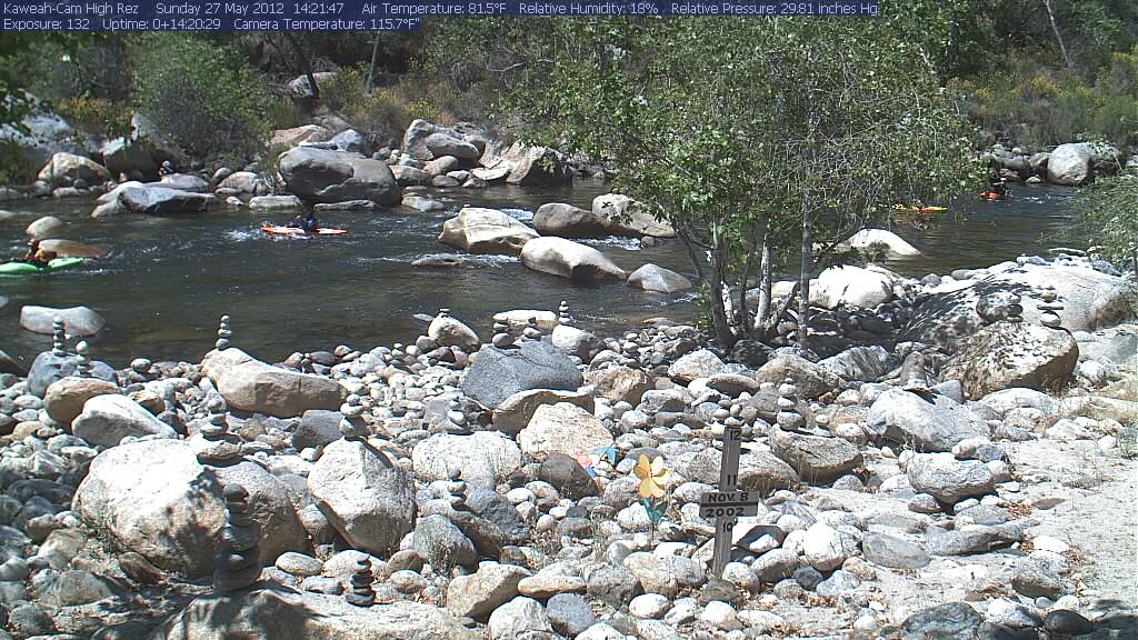
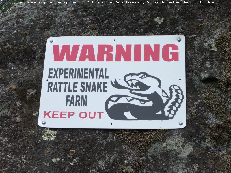
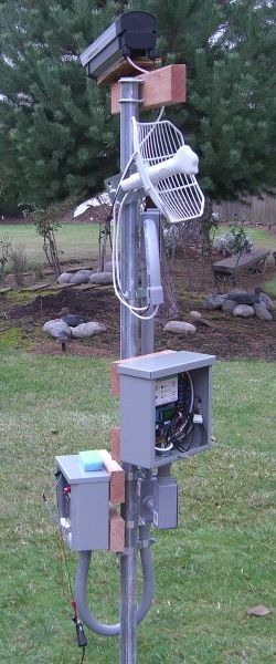
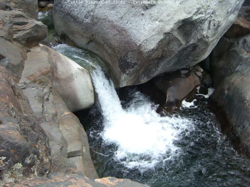
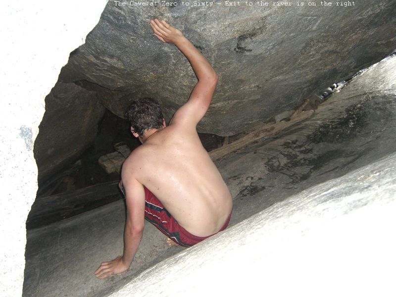
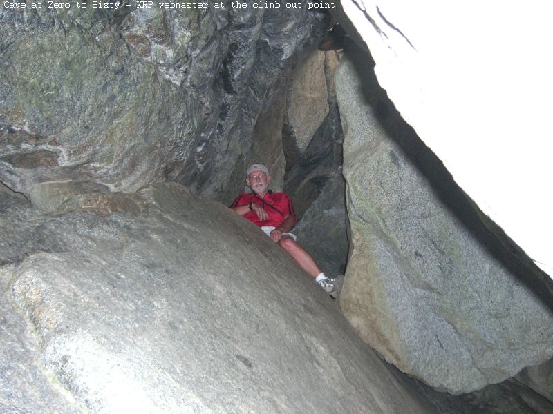
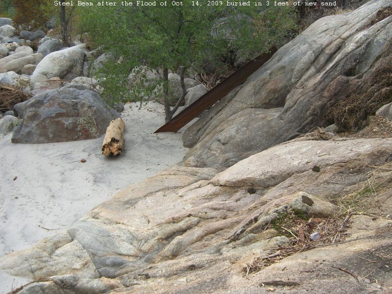
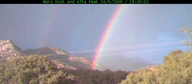
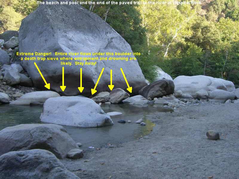
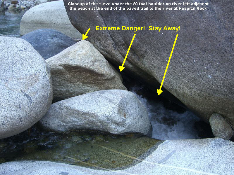
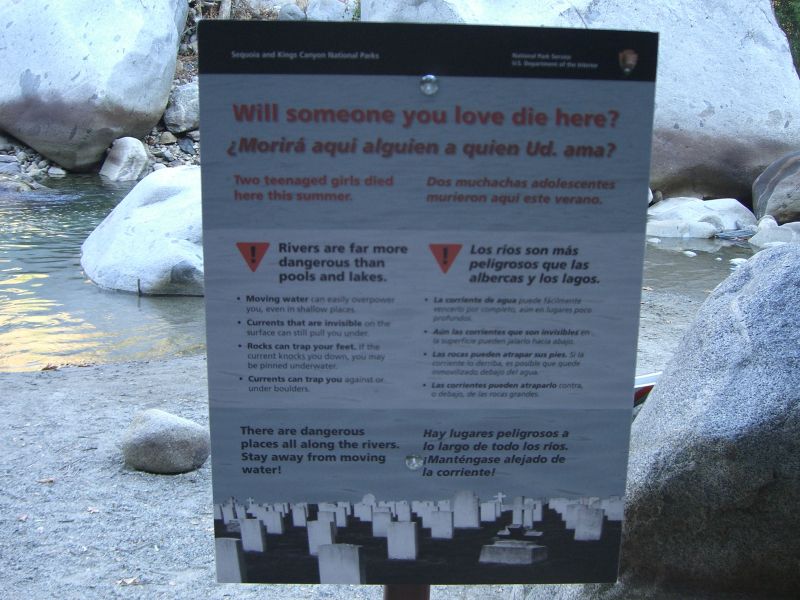
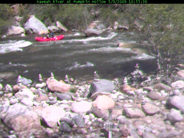
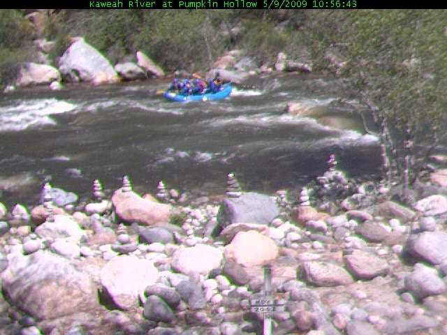
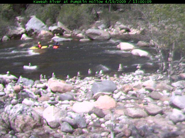
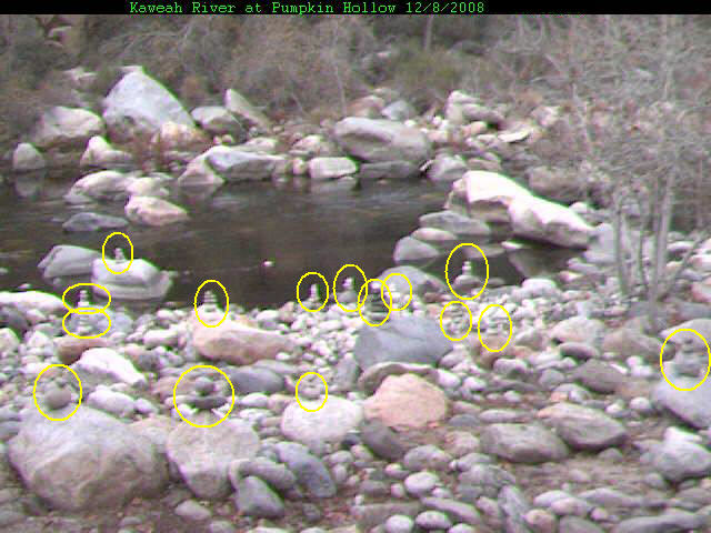
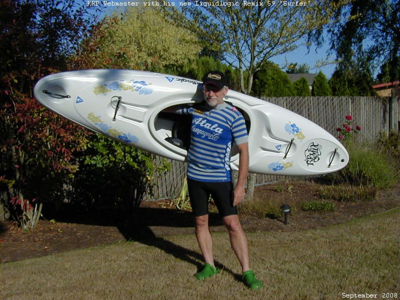
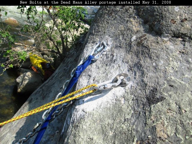
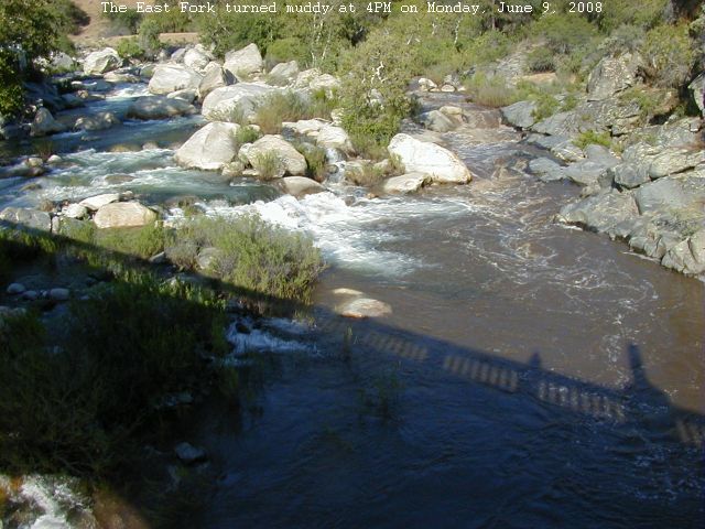
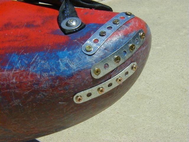
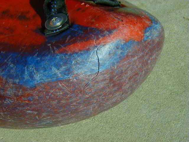
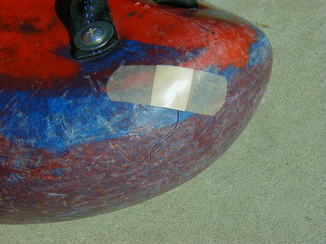
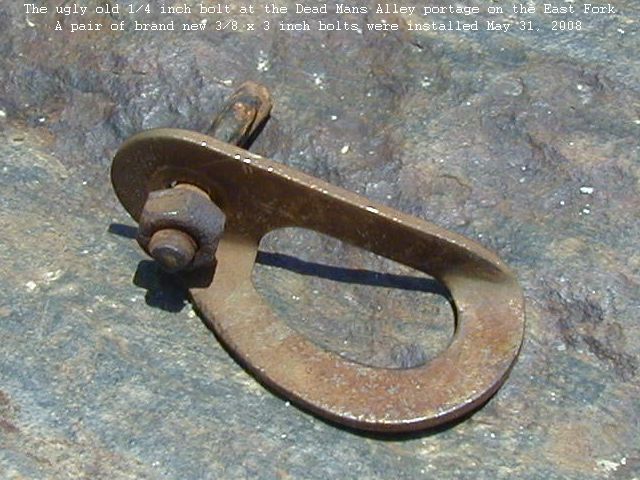
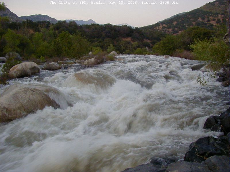
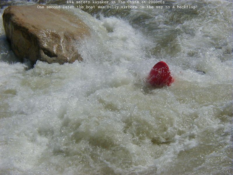
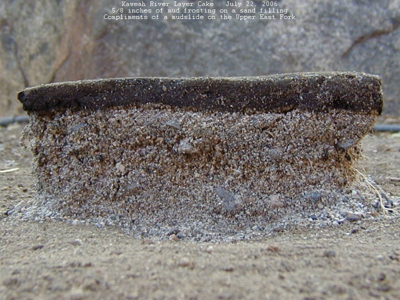
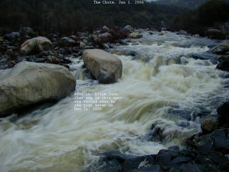
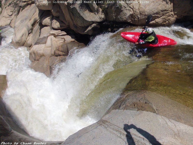
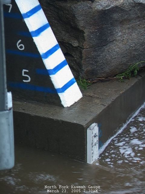
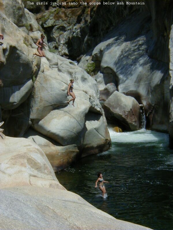
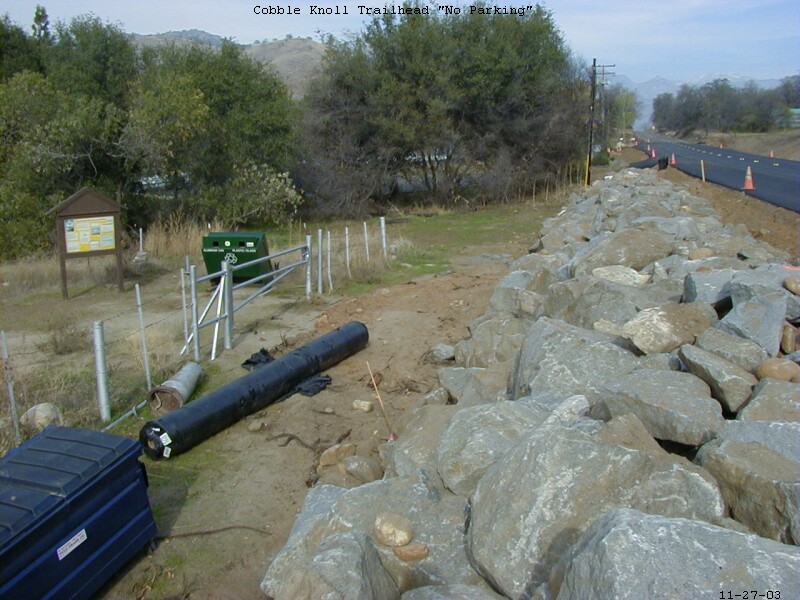
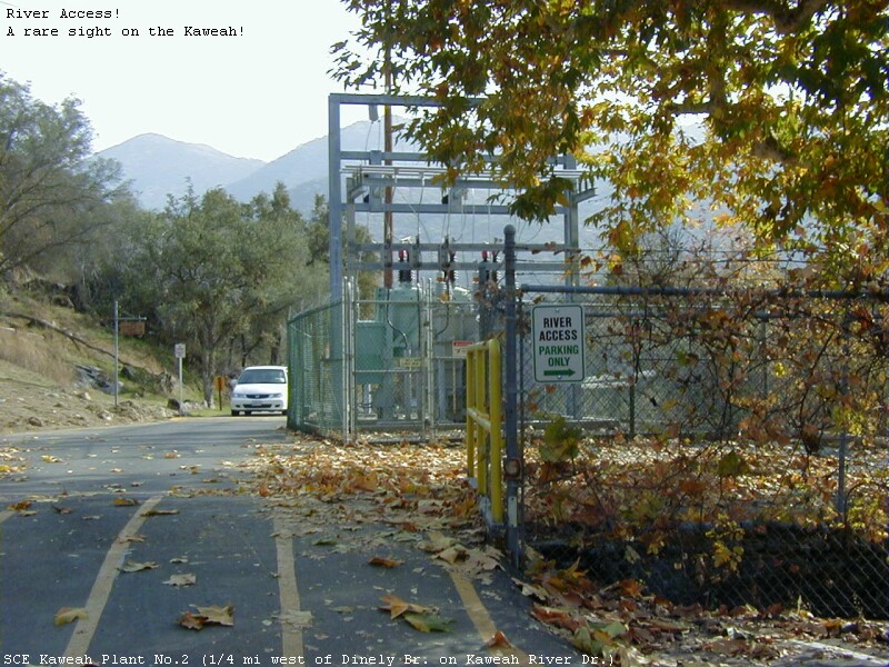
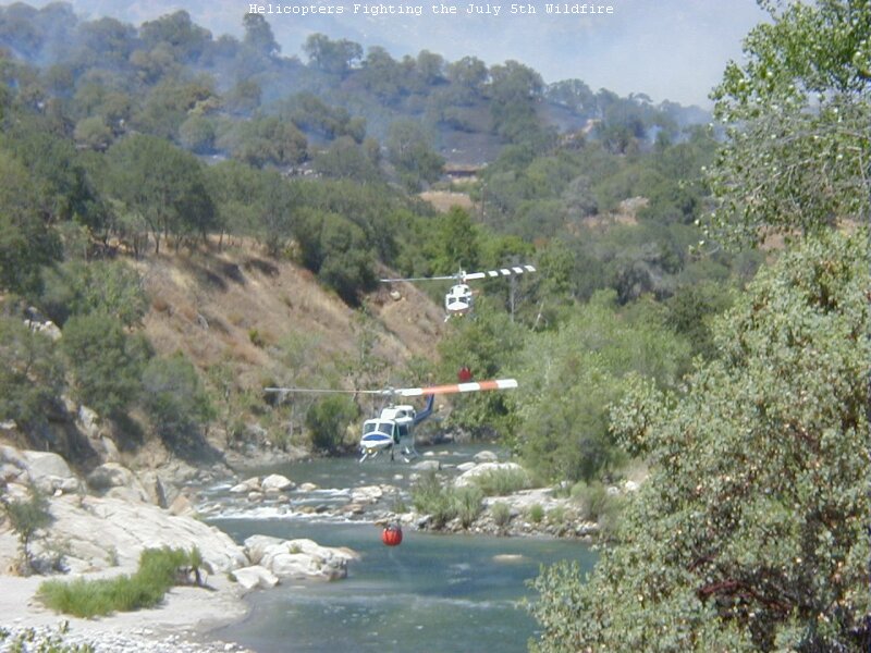
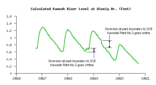
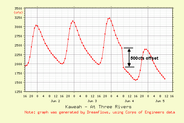
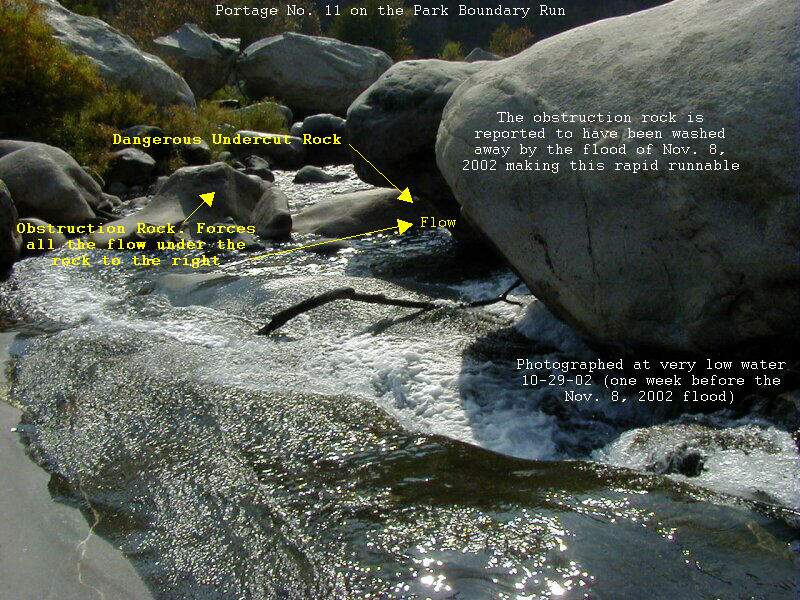
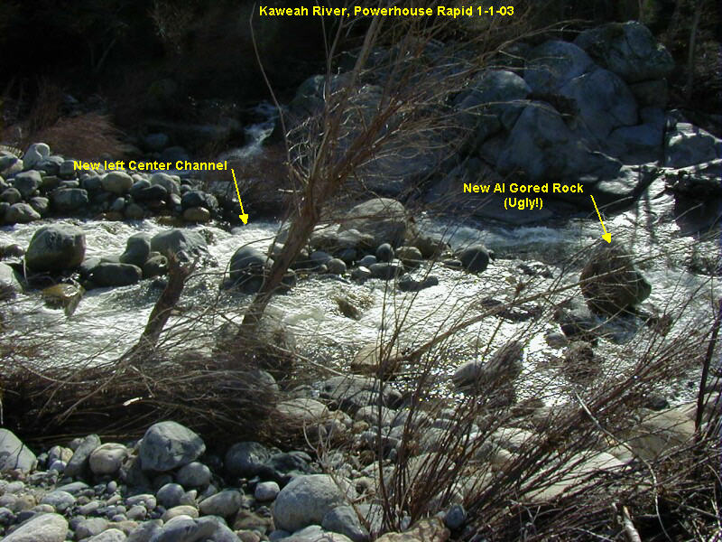
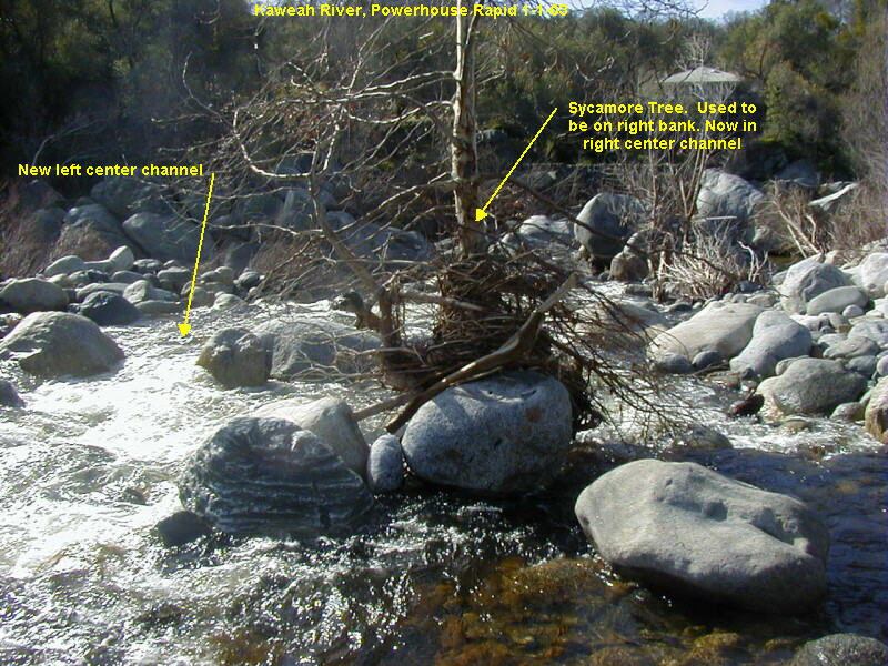
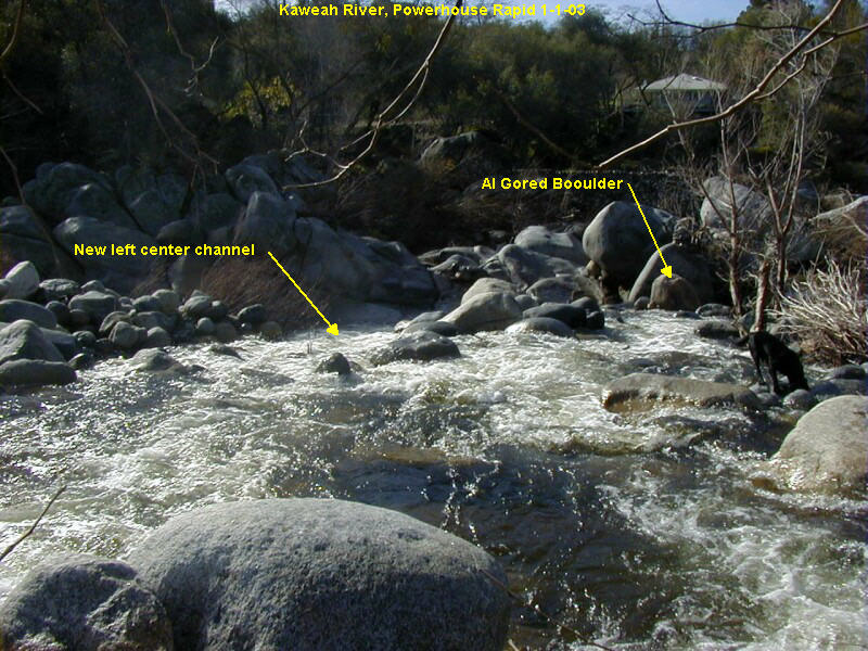
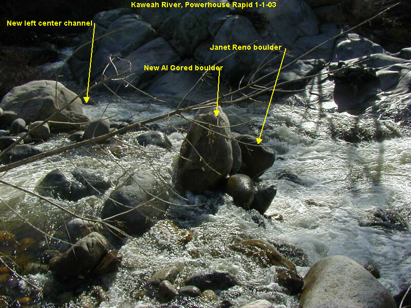
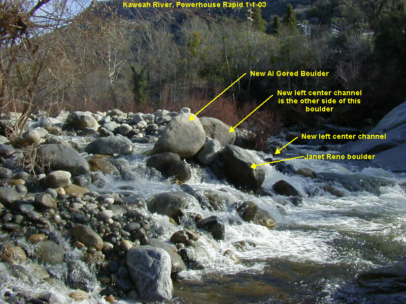
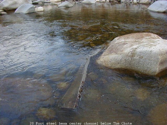
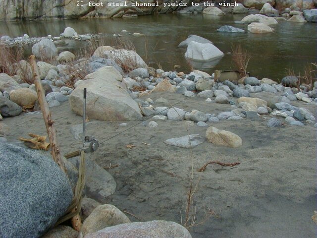
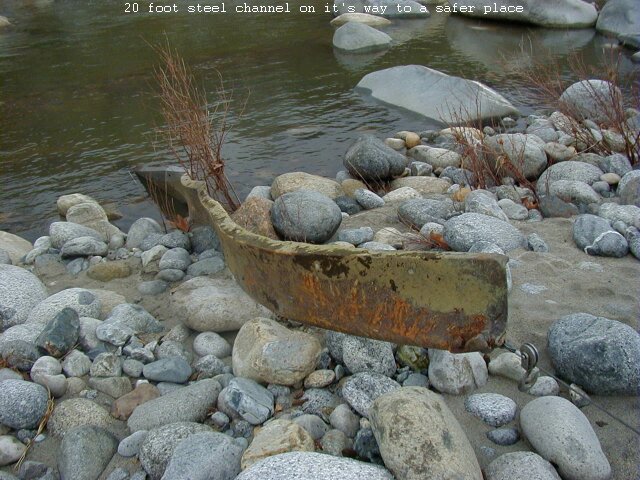
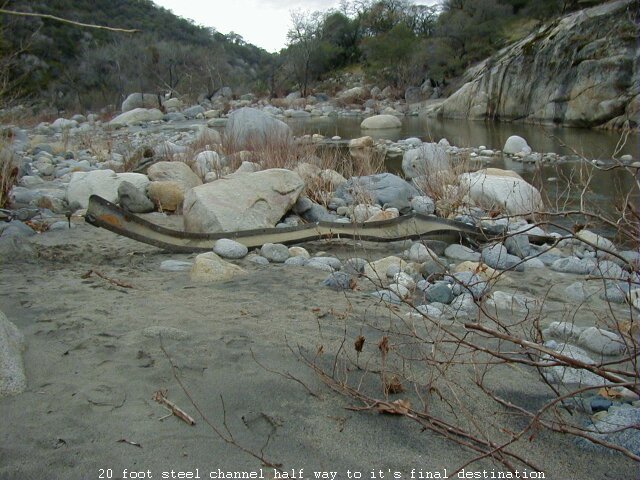
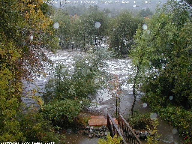
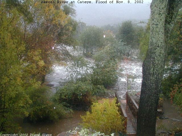
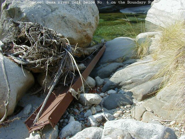
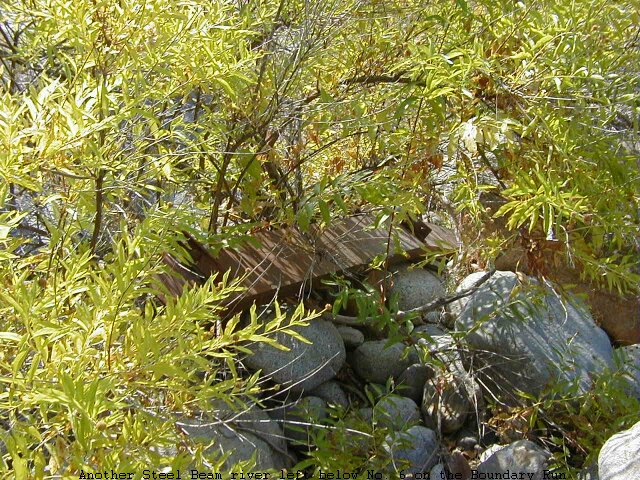
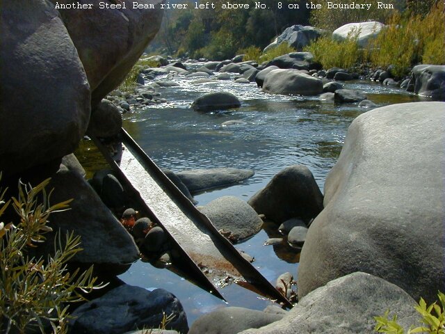
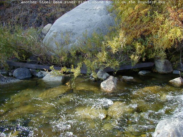
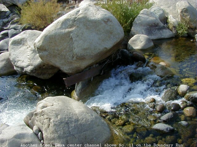
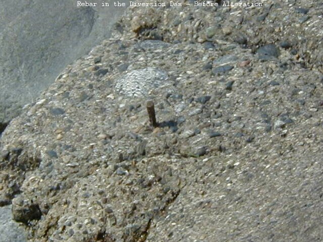
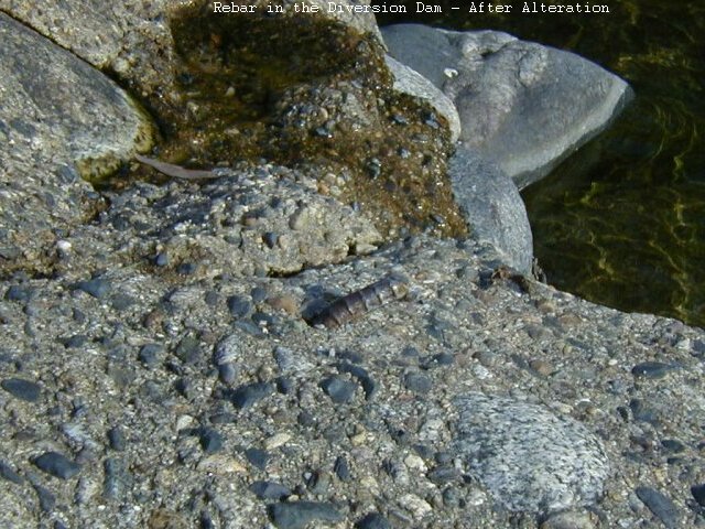
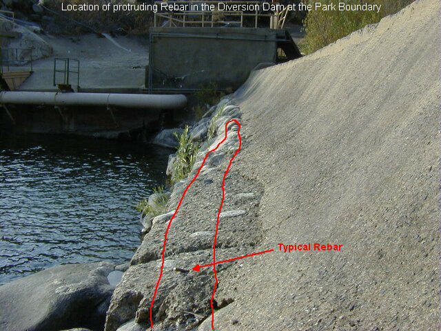
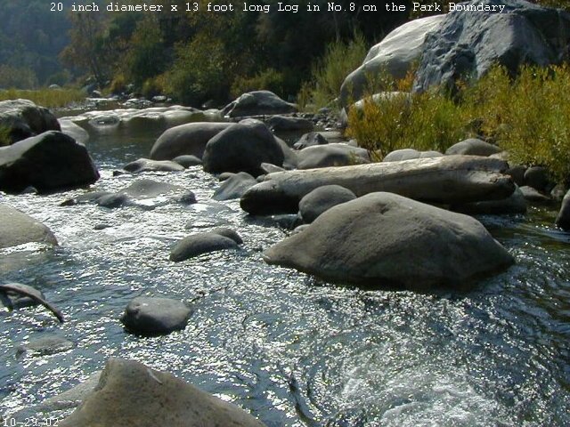
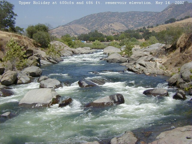
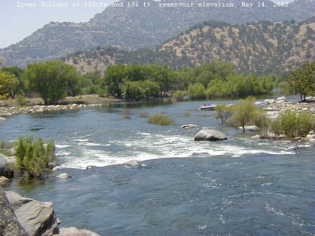
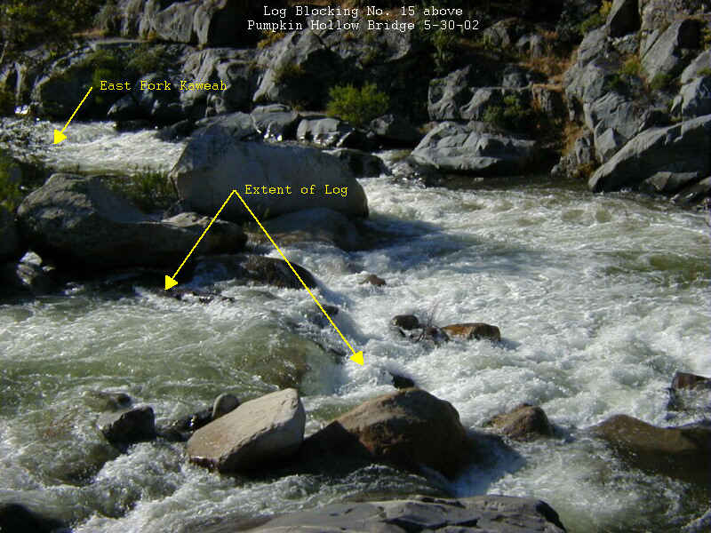
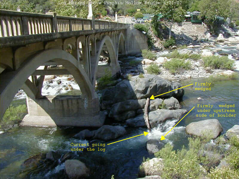
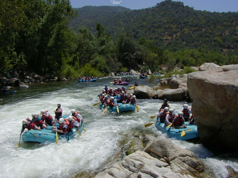
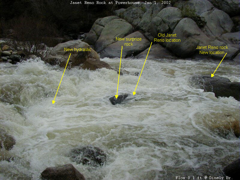
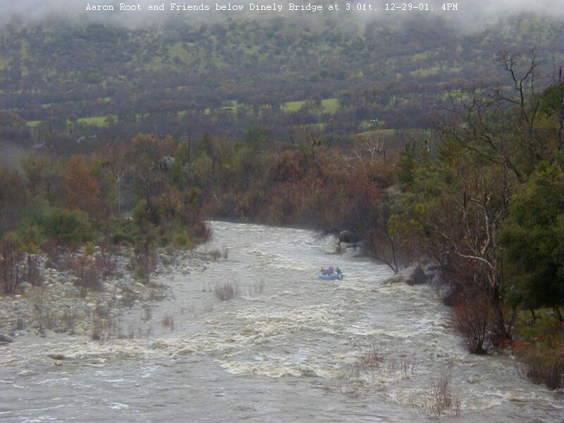
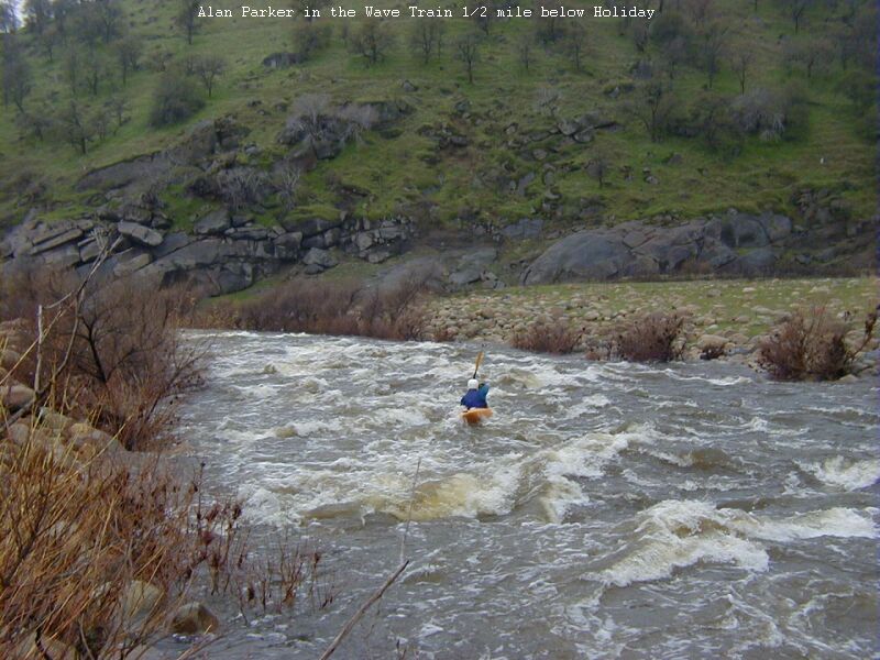
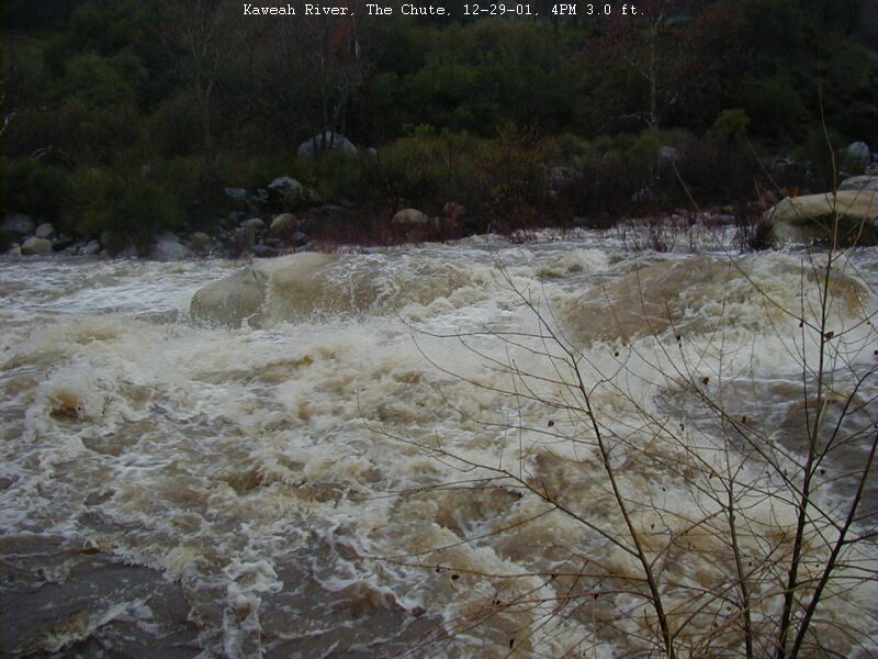
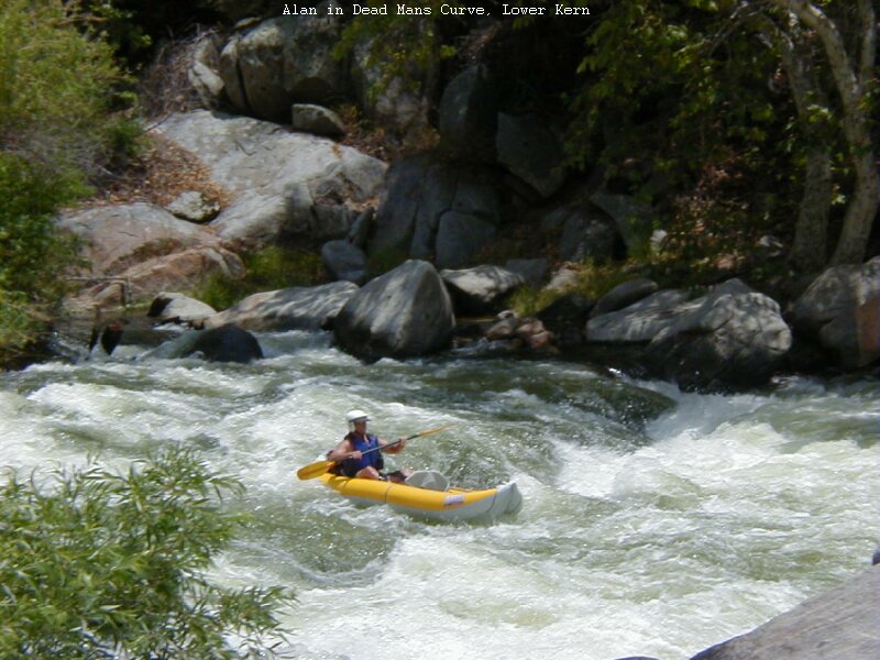
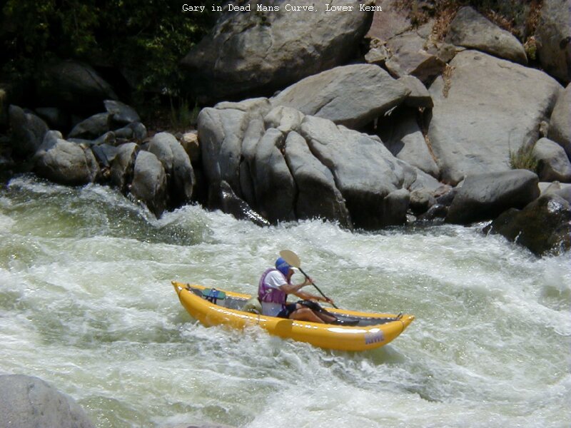
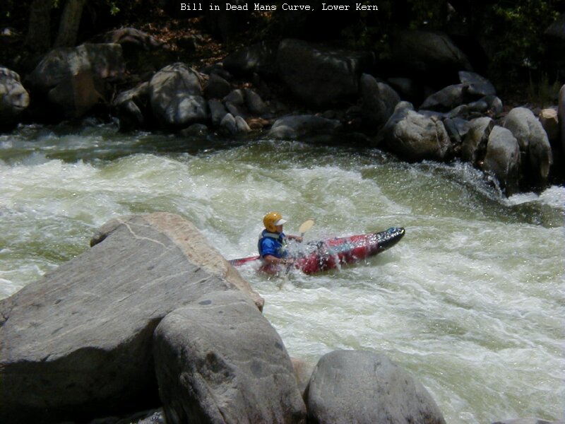
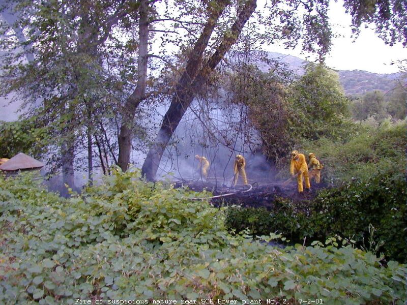
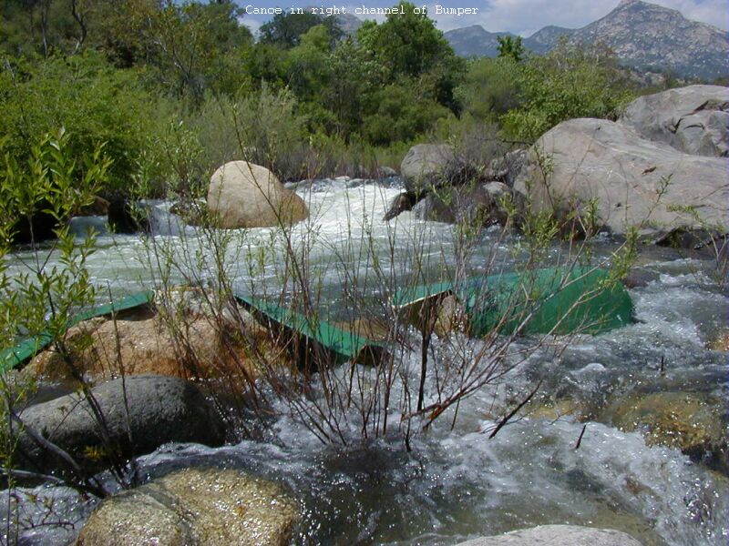
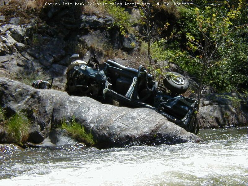
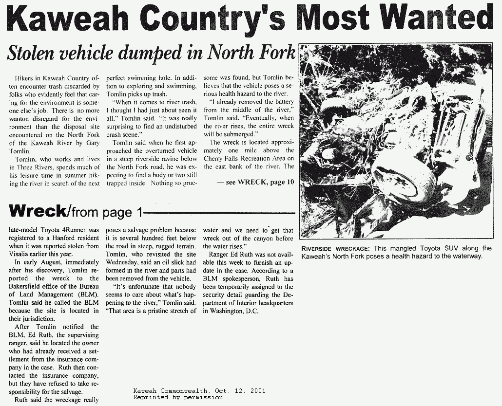
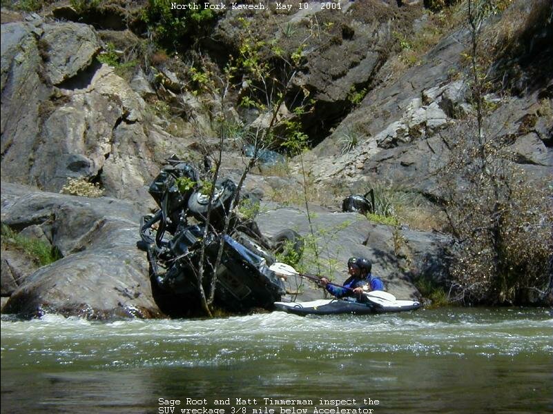
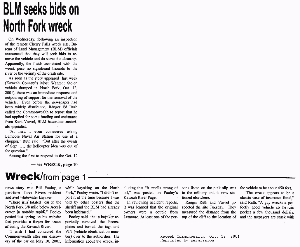
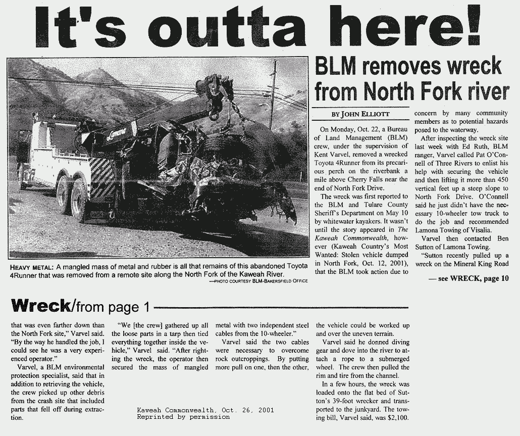
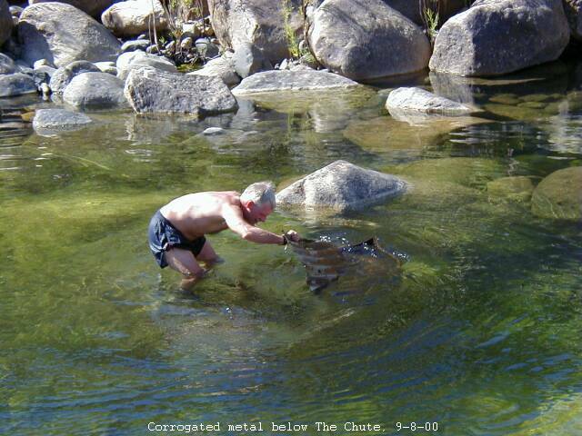
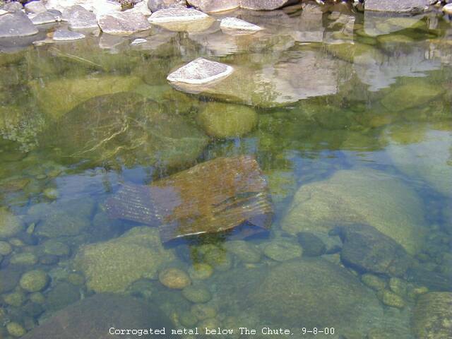
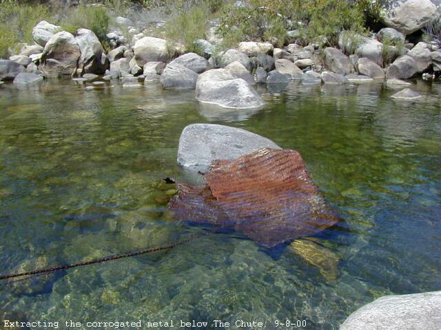
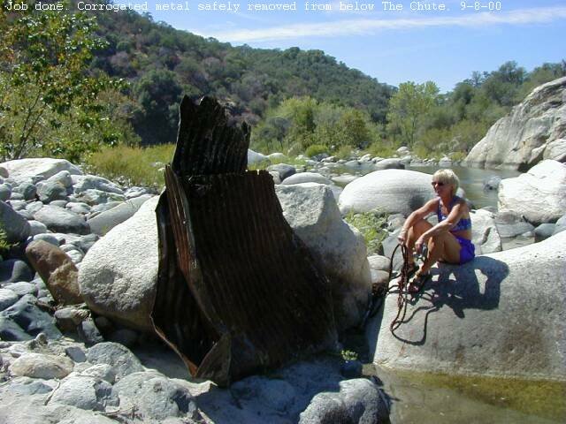
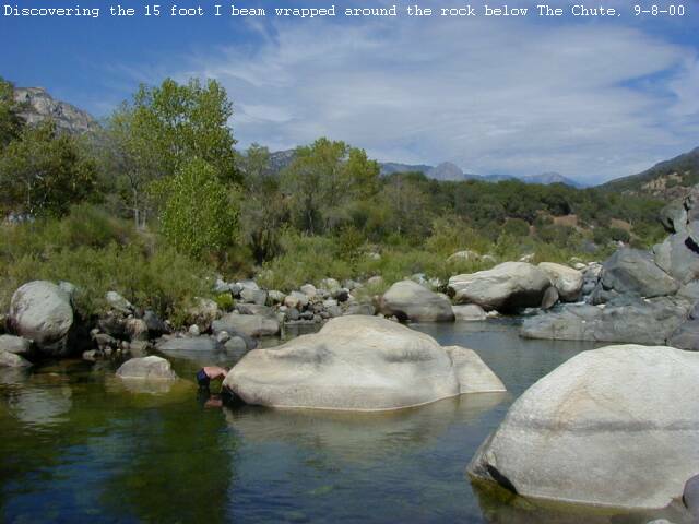